You are here: Home > Network List > TA - USArray Transportable Network (new EarthScope stations) Stations List
> Station S29A Ulysses, KS, USA > Earthquake Result Viewer
S29A Ulysses, KS, USA - Earthquake Result Viewer
| Earthquake location: |
Off Coast Of Ecuador |
| Earthquake latitude/longitude: |
1.4/-85.2 |
| Earthquake time(UTC): |
2009/05/10 (130) 01:16:06 GMT |
| Earthquake Depth: |
6.0 km |
| Earthquake Magnitude: |
5.5 MB, 5.7 MS, 6.1 MW, 6.1 MW |
| Earthquake Catalog/Contributor: |
WHDF/NEIC |
|
| Network: |
TA USArray Transportable Network (new EarthScope stations) |
| Station: |
S29A Ulysses, KS, USA |
| Lat/Lon: |
37.62 N/101.12 W |
| Elevation: |
931 m |
|
| Distance: |
38.9 deg |
| Az: |
339.681 deg |
| Baz: |
154.075 deg |
| Ray Param: |
0.075289354 |
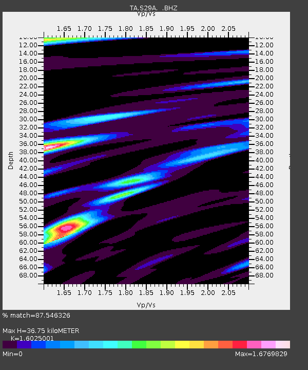
| Estimated Moho Depth: |
36.75 km |
| Estimated Crust Vp/Vs: |
1.60 |
| Assumed Crust Vp: |
6.483 km/s |
| Estimated Crust Vs: |
4.045 km/s |
| Estimated Crust Poisson's Ratio: |
0.18 |
|
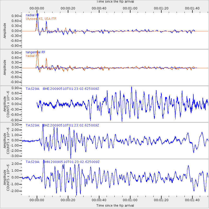
| Radial Match: |
87.546326 % |
| Radial Bump: |
308 |
| Transverse Match: |
86.536964 % |
| Transverse Bump: |
398 |
| SOD ConfigId: |
2760 |
| Insert Time: |
2010-03-06 01:44:03.499 +0000 |
| GWidth: |
2.5 |
| Max Bumps: |
400 |
| Tol: |
0.001 |
|
Signal To Noise
| Channel | StoN | STA | LTA |
| TA:S29A: :BHZ:20090510T01:23:02.625009Z | 14.440876 | 1.1177559E-6 | 7.740223E-8 |
| TA:S29A: :BHN:20090510T01:23:02.625009Z | 8.265297 | 8.568562E-7 | 1.0366913E-7 |
| TA:S29A: :BHE:20090510T01:23:02.625009Z | 2.7929204 | 2.9874093E-7 | 1.0696364E-7 |
| Arrivals |
| Ps | 3.7 SECOND |
| PpPs | 14 SECOND |
| PsPs/PpSs | 17 SECOND |


