You are here: Home > Network List > TA - USArray Transportable Network (new EarthScope stations) Stations List
> Station S29A Ulysses, KS, USA > Earthquake Result Viewer
S29A Ulysses, KS, USA - Earthquake Result Viewer
| Earthquake location: |
Hokkaido, Japan Region |
| Earthquake latitude/longitude: |
41.8/143.4 |
| Earthquake time(UTC): |
2009/06/05 (156) 03:30:33 GMT |
| Earthquake Depth: |
29 km |
| Earthquake Magnitude: |
6.0 MB, 6.3 MS, 6.4 MW, 6.4 MW |
| Earthquake Catalog/Contributor: |
WHDF/NEIC |
|
| Network: |
TA USArray Transportable Network (new EarthScope stations) |
| Station: |
S29A Ulysses, KS, USA |
| Lat/Lon: |
37.62 N/101.12 W |
| Elevation: |
931 m |
|
| Distance: |
81.4 deg |
| Az: |
46.482 deg |
| Baz: |
316.955 deg |
| Ray Param: |
0.04755105 |
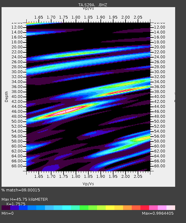
| Estimated Moho Depth: |
45.75 km |
| Estimated Crust Vp/Vs: |
1.76 |
| Assumed Crust Vp: |
6.483 km/s |
| Estimated Crust Vs: |
3.689 km/s |
| Estimated Crust Poisson's Ratio: |
0.26 |
|
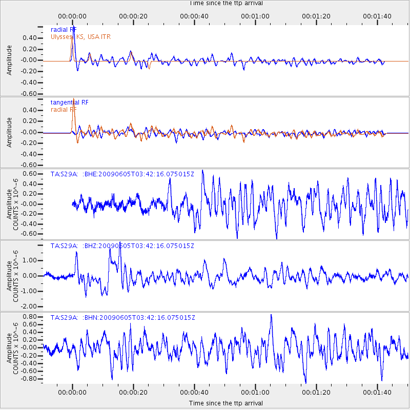
| Radial Match: |
89.80015 % |
| Radial Bump: |
400 |
| Transverse Match: |
70.67338 % |
| Transverse Bump: |
400 |
| SOD ConfigId: |
2648 |
| Insert Time: |
2010-03-06 01:44:22.237 +0000 |
| GWidth: |
2.5 |
| Max Bumps: |
400 |
| Tol: |
0.001 |
|
Signal To Noise
| Channel | StoN | STA | LTA |
| TA:S29A: :BHZ:20090605T03:42:16.075015Z | 6.016792 | 6.3564903E-7 | 1.0564584E-7 |
| TA:S29A: :BHN:20090605T03:42:16.075015Z | 2.7391186 | 2.1963406E-7 | 8.0184215E-8 |
| TA:S29A: :BHE:20090605T03:42:16.075015Z | 2.2901156 | 2.058628E-7 | 8.9891884E-8 |
| Arrivals |
| Ps | 5.5 SECOND |
| PpPs | 19 SECOND |
| PsPs/PpSs | 24 SECOND |


