You are here: Home > Network List > TA - USArray Transportable Network (new EarthScope stations) Stations List
> Station S29A Ulysses, KS, USA > Earthquake Result Viewer
S29A Ulysses, KS, USA - Earthquake Result Viewer
| Earthquake location: |
Baffin Bay |
| Earthquake latitude/longitude: |
75.4/-72.5 |
| Earthquake time(UTC): |
2009/07/07 (188) 19:11:46 GMT |
| Earthquake Depth: |
19 km |
| Earthquake Magnitude: |
5.9 MB, 5.7 MS, 6.1 MW, 6.0 MW |
| Earthquake Catalog/Contributor: |
WHDF/NEIC |
|
| Network: |
TA USArray Transportable Network (new EarthScope stations) |
| Station: |
S29A Ulysses, KS, USA |
| Lat/Lon: |
37.62 N/101.12 W |
| Elevation: |
931 m |
|
| Distance: |
40.1 deg |
| Az: |
216.27 deg |
| Baz: |
10.93 deg |
| Ray Param: |
0.0745764 |
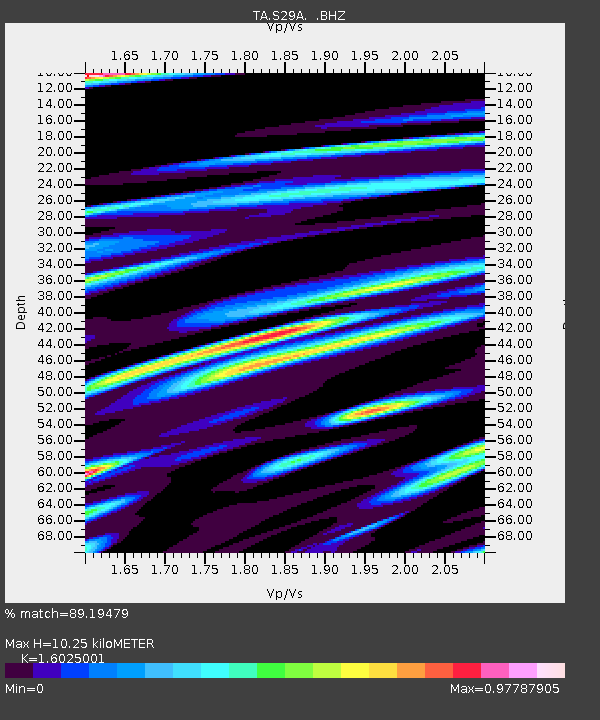
| Estimated Moho Depth: |
10.25 km |
| Estimated Crust Vp/Vs: |
1.60 |
| Assumed Crust Vp: |
6.483 km/s |
| Estimated Crust Vs: |
4.045 km/s |
| Estimated Crust Poisson's Ratio: |
0.18 |
|
| Radial Match: |
89.19479 % |
| Radial Bump: |
400 |
| Transverse Match: |
73.98376 % |
| Transverse Bump: |
400 |
| SOD ConfigId: |
2648 |
| Insert Time: |
2010-03-06 01:44:24.068 +0000 |
| GWidth: |
2.5 |
| Max Bumps: |
400 |
| Tol: |
0.001 |
|

Signal To Noise
| Channel | StoN | STA | LTA |
| TA:S29A: :BHZ:20090707T19:18:50.048989Z | 7.9989753 | 1.2241674E-6 | 1.5304052E-7 |
| TA:S29A: :BHN:20090707T19:18:50.048989Z | 4.030238 | 9.217215E-7 | 2.287015E-7 |
| TA:S29A: :BHE:20090707T19:18:50.048989Z | 1.5964836 | 2.8354887E-7 | 1.7760837E-7 |
| Arrivals |
| Ps | 1.0 SECOND |
| PpPs | 3.8 SECOND |
| PsPs/PpSs | 4.8 SECOND |


