You are here: Home > Network List > TA - USArray Transportable Network (new EarthScope stations) Stations List
> Station S29A Ulysses, KS, USA > Earthquake Result Viewer
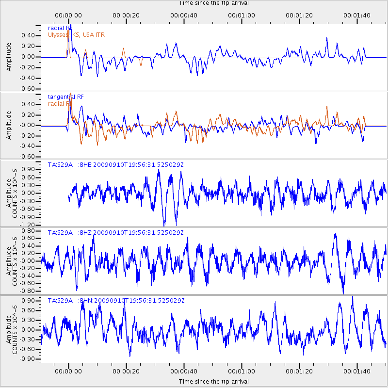
S29A Ulysses, KS, USA - Earthquake Result Viewer
*The percent match for this event was below the threshold and hence no stack was calculated.
| Earthquake location: |
Easter Island Region |
| Earthquake latitude/longitude: |
-29.9/-111.8 |
| Earthquake time(UTC): |
2009/09/10 (253) 19:46:03 GMT |
| Earthquake Depth: |
10 km |
| Earthquake Magnitude: |
5.5 MW, 5.4 MB |
| Earthquake Catalog/Contributor: |
WHDF/NEIC |
|
| Network: |
TA USArray Transportable Network (new EarthScope stations) |
| Station: |
S29A Ulysses, KS, USA |
| Lat/Lon: |
37.62 N/101.12 W |
| Elevation: |
931 m |
|
| Distance: |
67.9 deg |
| Az: |
9.158 deg |
| Baz: |
190.021 deg |
| Ray Param: |
$rayparam |
*The percent match for this event was below the threshold and hence was not used in the summary stack. |
|
| Radial Match: |
44.1866 % |
| Radial Bump: |
400 |
| Transverse Match: |
52.4675 % |
| Transverse Bump: |
400 |
| SOD ConfigId: |
2622 |
| Insert Time: |
2010-03-06 01:44:38.411 +0000 |
| GWidth: |
2.5 |
| Max Bumps: |
400 |
| Tol: |
0.001 |
|
Signal To Noise
| Channel | StoN | STA | LTA |
| TA:S29A: :BHZ:20090910T19:56:31.525029Z | 1.4560766 | 2.981793E-7 | 2.0478268E-7 |
| TA:S29A: :BHN:20090910T19:56:31.525029Z | 1.5554408 | 4.4623437E-7 | 2.8688612E-7 |
| TA:S29A: :BHE:20090910T19:56:31.525029Z | 3.2752645 | 6.164445E-7 | 1.8821213E-7 |
| Arrivals |
| Ps | |
| PpPs | |
| PsPs/PpSs | |


