You are here: Home > Network List > TA - USArray Transportable Network (new EarthScope stations) Stations List
> Station S29A Ulysses, KS, USA > Earthquake Result Viewer
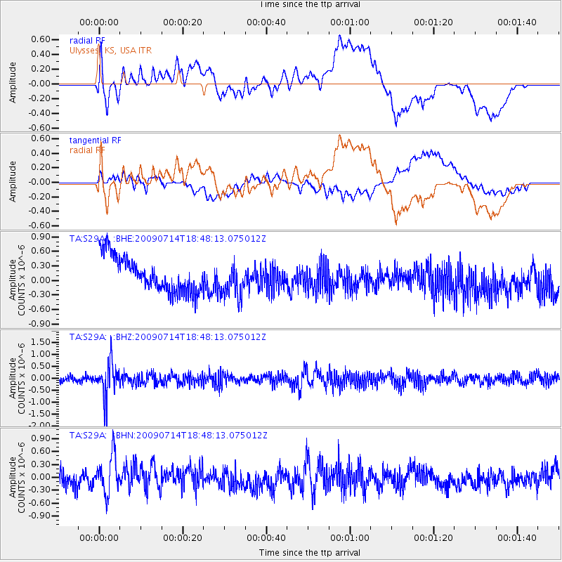
S29A Ulysses, KS, USA - Earthquake Result Viewer
*The percent match for this event was below the threshold and hence no stack was calculated.
| Earthquake location: |
Chile-Bolivia Border Region |
| Earthquake latitude/longitude: |
-21.8/-67.1 |
| Earthquake time(UTC): |
2009/07/14 (195) 18:38:08 GMT |
| Earthquake Depth: |
176 km |
| Earthquake Magnitude: |
5.7 MW, 5.4 MB, 5.7 MW |
| Earthquake Catalog/Contributor: |
WHDF/NEIC |
|
| Network: |
TA USArray Transportable Network (new EarthScope stations) |
| Station: |
S29A Ulysses, KS, USA |
| Lat/Lon: |
37.62 N/101.12 W |
| Elevation: |
931 m |
|
| Distance: |
67.2 deg |
| Az: |
331.19 deg |
| Baz: |
145.673 deg |
| Ray Param: |
$rayparam |
*The percent match for this event was below the threshold and hence was not used in the summary stack. |
|
| Radial Match: |
55.42181 % |
| Radial Bump: |
400 |
| Transverse Match: |
63.376377 % |
| Transverse Bump: |
400 |
| SOD ConfigId: |
2648 |
| Insert Time: |
2010-03-06 01:44:55.535 +0000 |
| GWidth: |
2.5 |
| Max Bumps: |
400 |
| Tol: |
0.001 |
|
Signal To Noise
| Channel | StoN | STA | LTA |
| TA:S29A: :BHZ:20090714T18:48:13.075012Z | 5.2928467 | 7.08605E-7 | 1.3387975E-7 |
| TA:S29A: :BHN:20090714T18:48:13.075012Z | 1.5919209 | 4.725784E-7 | 2.9686046E-7 |
| TA:S29A: :BHE:20090714T18:48:13.075012Z | 1.0043445 | 3.5913894E-7 | 3.5758544E-7 |
| Arrivals |
| Ps | |
| PpPs | |
| PsPs/PpSs | |


