You are here: Home > Network List > TA - USArray Transportable Network (new EarthScope stations) Stations List
> Station S30A Montezuma, KS, USA > Earthquake Result Viewer
S30A Montezuma, KS, USA - Earthquake Result Viewer
| Earthquake location: |
Near S. Coast Of Honshu, Japan |
| Earthquake latitude/longitude: |
33.2/137.9 |
| Earthquake time(UTC): |
2009/08/09 (221) 10:55:55 GMT |
| Earthquake Depth: |
297 km |
| Earthquake Magnitude: |
6.5 MB, 7.1 MW, 7.1 MW |
| Earthquake Catalog/Contributor: |
WHDF/NEIC |
|
| Network: |
TA USArray Transportable Network (new EarthScope stations) |
| Station: |
S30A Montezuma, KS, USA |
| Lat/Lon: |
37.64 N/100.46 W |
| Elevation: |
853 m |
|
| Distance: |
91.0 deg |
| Az: |
42.553 deg |
| Baz: |
314.394 deg |
| Ray Param: |
0.041527163 |
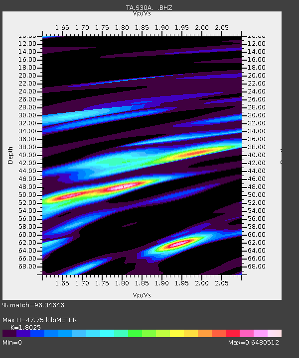
| Estimated Moho Depth: |
47.75 km |
| Estimated Crust Vp/Vs: |
1.80 |
| Assumed Crust Vp: |
6.483 km/s |
| Estimated Crust Vs: |
3.596 km/s |
| Estimated Crust Poisson's Ratio: |
0.28 |
|
| Radial Match: |
96.34646 % |
| Radial Bump: |
366 |
| Transverse Match: |
84.40331 % |
| Transverse Bump: |
400 |
| SOD ConfigId: |
2622 |
| Insert Time: |
2010-03-06 01:44:58.200 +0000 |
| GWidth: |
2.5 |
| Max Bumps: |
400 |
| Tol: |
0.001 |
|
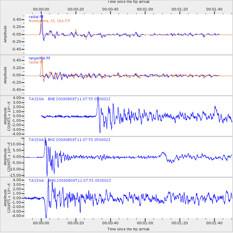
Signal To Noise
| Channel | StoN | STA | LTA |
| TA:S30A: :BHZ:20090809T11:07:55.050002Z | 79.27807 | 6.7856545E-6 | 8.5593086E-8 |
| TA:S30A: :BHN:20090809T11:07:55.050002Z | 20.200994 | 1.9844576E-6 | 9.8235645E-8 |
| TA:S30A: :BHE:20090809T11:07:55.050002Z | 20.554205 | 1.8224729E-6 | 8.866667E-8 |
| Arrivals |
| Ps | 6.0 SECOND |
| PpPs | 20 SECOND |
| PsPs/PpSs | 26 SECOND |


