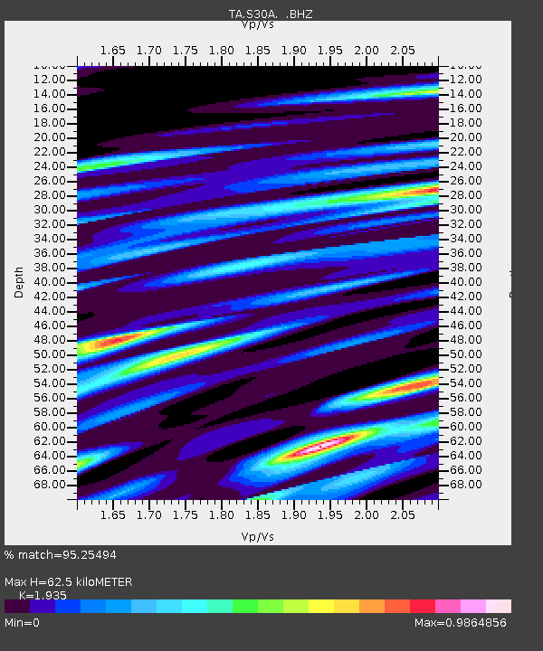
S30A Montezuma, KS, USA - Earthquake Result Viewer
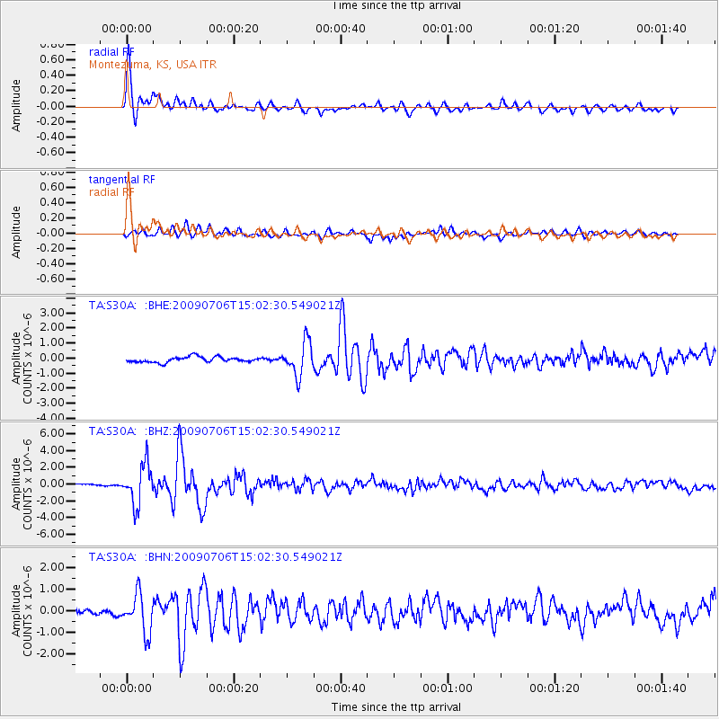
Earthquake location: Rat Islands, Aleutian Islands
Earthquake latitude/longitude: 50.4/177.0
Earthquake time(UTC): 2009/07/06 (187) 14:53:12 GMT
Earthquake Depth: 22 km
Earthquake Magnitude: 6.0 MB, 5.8 MS, 6.1 MW, 6.0 MW
Earthquake Catalog/Contributor: WHDF/NEIC
Network: TA USArray Transportable Network (new EarthScope stations)
Station: S30A Montezuma, KS, USA
Lat/Lon: 37.64 N/100.46 W
Elevation: 853 m
Distance: 57.8 deg
Az: 68.523 deg
Baz: 311.441 deg
Ray Param: 0.0632549
Estimated Moho Depth: 62.5 km
Estimated Crust Vp/Vs: 1.93
Assumed Crust Vp: 6.483 km/s
Estimated Crust Vs: 3.35 km/s
Estimated Crust Poisson's Ratio: 0.32
Radial Match: 95.25494 %
Radial Bump: 400
Transverse Match: 71.75672 %
Transverse Bump: 400
SOD ConfigId: 2648
Insert Time: 2010-03-06 01:45:11.278 +0000
GWidth: 2.5
Max Bumps: 400
Tol: 0.001

Signal To Noise

ChannelStoNSTALTA
TA:S30A: :BHZ:20090706T15:02:30.549021Z17.0336692.391976E-61.4042637E-7
TA:S30A: :BHN:20090706T15:02:30.549021Z5.0727118.9627616E-71.7668584E-7
TA:S30A: :BHE:20090706T15:02:30.549021Z6.2248021.1261329E-61.8091065E-7
Arrivals
Ps9.4 SECOND
PpPs27 SECOND
PsPs/PpSs36 SECOND