You are here: Home > Network List > TA - USArray Transportable Network (new EarthScope stations) Stations List
> Station S30A Montezuma, KS, USA > Earthquake Result Viewer
S30A Montezuma, KS, USA - Earthquake Result Viewer
| Earthquake location: |
Baffin Bay |
| Earthquake latitude/longitude: |
75.4/-72.5 |
| Earthquake time(UTC): |
2009/07/07 (188) 19:11:46 GMT |
| Earthquake Depth: |
19 km |
| Earthquake Magnitude: |
5.9 MB, 5.7 MS, 6.1 MW, 6.0 MW |
| Earthquake Catalog/Contributor: |
WHDF/NEIC |
|
| Network: |
TA USArray Transportable Network (new EarthScope stations) |
| Station: |
S30A Montezuma, KS, USA |
| Lat/Lon: |
37.64 N/100.46 W |
| Elevation: |
853 m |
|
| Distance: |
40.0 deg |
| Az: |
215.483 deg |
| Baz: |
10.724 deg |
| Ray Param: |
0.07464933 |
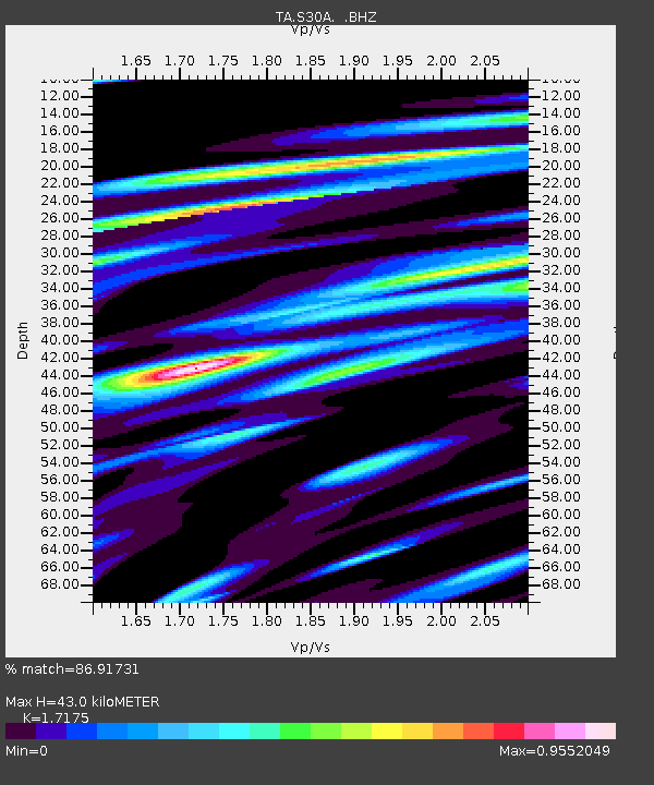
| Estimated Moho Depth: |
43.0 km |
| Estimated Crust Vp/Vs: |
1.72 |
| Assumed Crust Vp: |
6.483 km/s |
| Estimated Crust Vs: |
3.774 km/s |
| Estimated Crust Poisson's Ratio: |
0.24 |
|
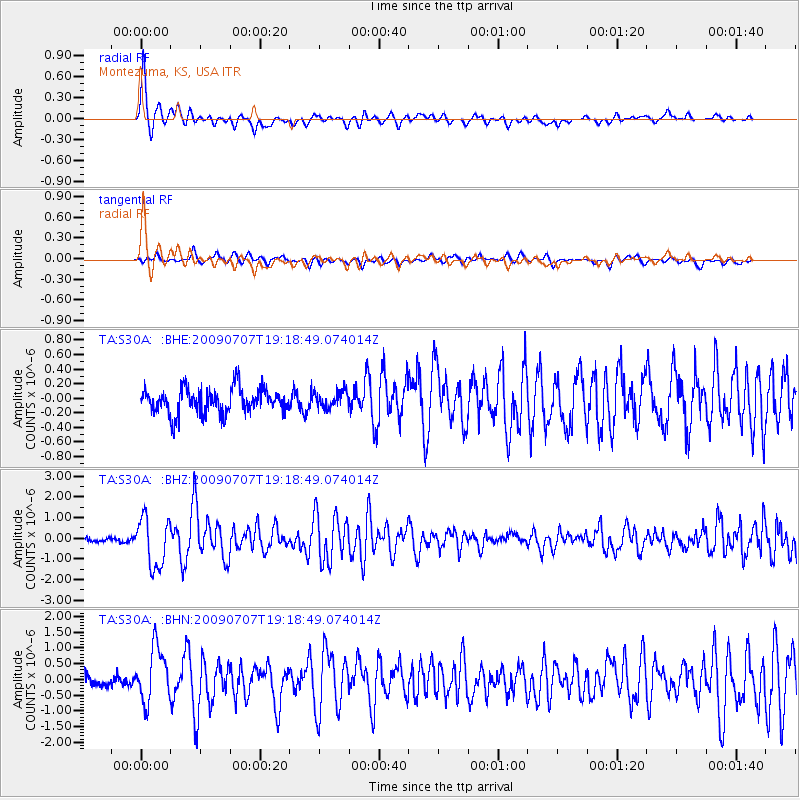
| Radial Match: |
86.91731 % |
| Radial Bump: |
388 |
| Transverse Match: |
75.902016 % |
| Transverse Bump: |
360 |
| SOD ConfigId: |
2648 |
| Insert Time: |
2010-03-06 01:45:13.728 +0000 |
| GWidth: |
2.5 |
| Max Bumps: |
400 |
| Tol: |
0.001 |
|
Signal To Noise
| Channel | StoN | STA | LTA |
| TA:S30A: :BHZ:20090707T19:18:49.074014Z | 13.9799795 | 1.183752E-6 | 8.46748E-8 |
| TA:S30A: :BHN:20090707T19:18:49.074014Z | 5.9522824 | 8.5544616E-7 | 1.4371734E-7 |
| TA:S30A: :BHE:20090707T19:18:49.074014Z | 0.6659838 | 1.14435E-7 | 1.718285E-7 |
| Arrivals |
| Ps | 5.1 SECOND |
| PpPs | 17 SECOND |
| PsPs/PpSs | 22 SECOND |


