You are here: Home > Network List > TA - USArray Transportable Network (new EarthScope stations) Stations List
> Station S30A Montezuma, KS, USA > Earthquake Result Viewer
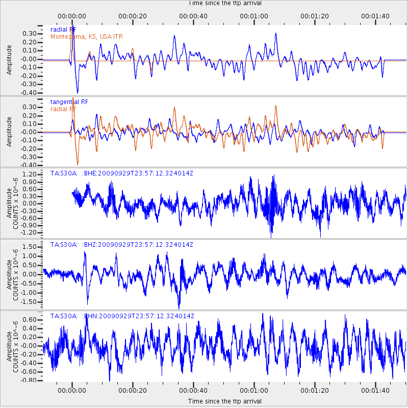
S30A Montezuma, KS, USA - Earthquake Result Viewer
*The percent match for this event was below the threshold and hence no stack was calculated.
| Earthquake location: |
Samoa Islands Region |
| Earthquake latitude/longitude: |
-15.8/-172.6 |
| Earthquake time(UTC): |
2009/09/29 (272) 23:45:03 GMT |
| Earthquake Depth: |
10 km |
| Earthquake Magnitude: |
6.0 MB, 5.8 MS |
| Earthquake Catalog/Contributor: |
WHDF/NEIC |
|
| Network: |
TA USArray Transportable Network (new EarthScope stations) |
| Station: |
S30A Montezuma, KS, USA |
| Lat/Lon: |
37.64 N/100.46 W |
| Elevation: |
853 m |
|
| Distance: |
86.0 deg |
| Az: |
49.22 deg |
| Baz: |
246.656 deg |
| Ray Param: |
$rayparam |
*The percent match for this event was below the threshold and hence was not used in the summary stack. |
|
| Radial Match: |
71.56469 % |
| Radial Bump: |
400 |
| Transverse Match: |
54.9804 % |
| Transverse Bump: |
400 |
| SOD ConfigId: |
2622 |
| Insert Time: |
2010-03-06 01:45:23.077 +0000 |
| GWidth: |
2.5 |
| Max Bumps: |
400 |
| Tol: |
0.001 |
|
Signal To Noise
| Channel | StoN | STA | LTA |
| TA:S30A: :BHZ:20090929T23:57:12.324014Z | 2.2011044 | 4.15695E-7 | 1.8885747E-7 |
| TA:S30A: :BHN:20090929T23:57:12.324014Z | 0.838942 | 2.5326364E-7 | 3.0188457E-7 |
| TA:S30A: :BHE:20090929T23:57:12.324014Z | 0.67335874 | 2.0914796E-7 | 3.1060407E-7 |
| Arrivals |
| Ps | |
| PpPs | |
| PsPs/PpSs | |


