You are here: Home > Network List > AV - Alaska Volcano Observatory Stations List
> Station MAPS Pakushin Southeast, Makushin Volcano, Alaska > Earthquake Result Viewer
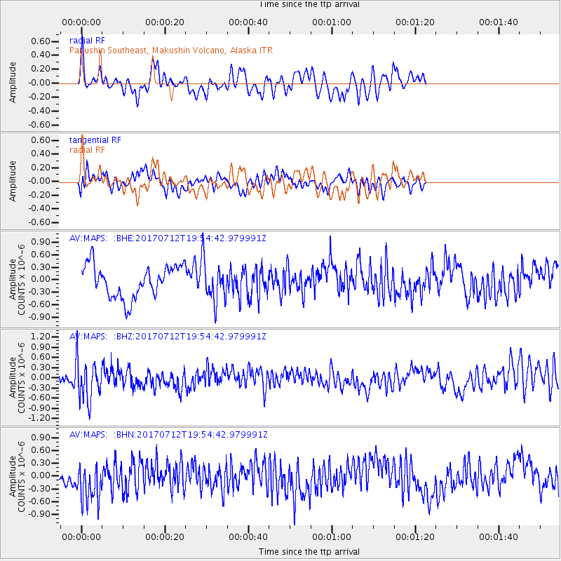
MAPS Pakushin Southeast, Makushin Volcano, Alaska - Earthquake Result Viewer
*The percent match for this event was below the threshold and hence no stack was calculated.
| Earthquake location: |
Sea Of Japan |
| Earthquake latitude/longitude: |
40.9/131.6 |
| Earthquake time(UTC): |
2017/07/12 (193) 19:48:07 GMT |
| Earthquake Depth: |
538 km |
| Earthquake Magnitude: |
5.8 Mww |
| Earthquake Catalog/Contributor: |
NEIC PDE/us |
|
| Network: |
AV Alaska Volcano Observatory |
| Station: |
MAPS Pakushin Southeast, Makushin Volcano, Alaska |
| Lat/Lon: |
53.81 N/166.94 W |
| Elevation: |
333 m |
|
| Distance: |
42.3 deg |
| Az: |
50.729 deg |
| Baz: |
278.064 deg |
| Ray Param: |
$rayparam |
*The percent match for this event was below the threshold and hence was not used in the summary stack. |
|
| Radial Match: |
59.74721 % |
| Radial Bump: |
400 |
| Transverse Match: |
45.00713 % |
| Transverse Bump: |
400 |
| SOD ConfigId: |
13570011 |
| Insert Time: |
2019-04-28 09:01:07.154 +0000 |
| GWidth: |
2.5 |
| Max Bumps: |
400 |
| Tol: |
0.001 |
|
Signal To Noise
| Channel | StoN | STA | LTA |
| AV:MAPS: :BHZ:20170712T19:54:42.979991Z | 2.7022083 | 5.371166E-7 | 1.9876951E-7 |
| AV:MAPS: :BHN:20170712T19:54:42.979991Z | 3.0637727 | 4.8579216E-7 | 1.5856013E-7 |
| AV:MAPS: :BHE:20170712T19:54:42.979991Z | 1.1642855 | 4.4749905E-7 | 3.8435508E-7 |
| Arrivals |
| Ps | |
| PpPs | |
| PsPs/PpSs | |


