You are here: Home > Network List > CC - Cascade Chain Volcano Monitoring Stations List
> Station OBSR Observation Rock, Mt. Rainier, WA > Earthquake Result Viewer
OBSR Observation Rock, Mt. Rainier, WA - Earthquake Result Viewer
| Earthquake location: |
Sea Of Japan |
| Earthquake latitude/longitude: |
40.9/131.6 |
| Earthquake time(UTC): |
2017/07/12 (193) 19:48:07 GMT |
| Earthquake Depth: |
538 km |
| Earthquake Magnitude: |
5.8 Mww |
| Earthquake Catalog/Contributor: |
NEIC PDE/us |
|
| Network: |
CC Cascade Chain Volcano Monitoring |
| Station: |
OBSR Observation Rock, Mt. Rainier, WA |
| Lat/Lon: |
46.90 N/121.82 W |
| Elevation: |
2382 m |
|
| Distance: |
71.0 deg |
| Az: |
44.054 deg |
| Baz: |
309.723 deg |
| Ray Param: |
0.05284735 |
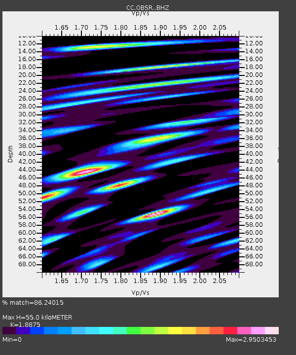
| Estimated Moho Depth: |
55.0 km |
| Estimated Crust Vp/Vs: |
1.89 |
| Assumed Crust Vp: |
6.597 km/s |
| Estimated Crust Vs: |
3.495 km/s |
| Estimated Crust Poisson's Ratio: |
0.30 |
|
| Radial Match: |
86.24015 % |
| Radial Bump: |
400 |
| Transverse Match: |
86.9199 % |
| Transverse Bump: |
400 |
| SOD ConfigId: |
13570011 |
| Insert Time: |
2019-04-28 09:02:00.678 +0000 |
| GWidth: |
2.5 |
| Max Bumps: |
400 |
| Tol: |
0.001 |
|

Signal To Noise
| Channel | StoN | STA | LTA |
| CC:OBSR: :BHZ:20170712T19:57:59.420024Z | 44.45808 | 2.0081281E-6 | 4.5169028E-8 |
| CC:OBSR: :BHN:20170712T19:57:59.420024Z | 18.848007 | 1.8422112E-6 | 9.774037E-8 |
| CC:OBSR: :BHE:20170712T19:57:59.420024Z | 11.442592 | 1.2936301E-6 | 1.1305394E-7 |
| Arrivals |
| Ps | 7.7 SECOND |
| PpPs | 23 SECOND |
| PsPs/PpSs | 31 SECOND |


