You are here: Home > Network List > TA - USArray Transportable Network (new EarthScope stations) Stations List
> Station R28A Tribune, KS, USA > Earthquake Result Viewer
R28A Tribune, KS, USA - Earthquake Result Viewer
| Earthquake location: |
Off Coast Of Ecuador |
| Earthquake latitude/longitude: |
1.4/-85.2 |
| Earthquake time(UTC): |
2009/05/10 (130) 01:16:06 GMT |
| Earthquake Depth: |
6.0 km |
| Earthquake Magnitude: |
5.5 MB, 5.7 MS, 6.1 MW, 6.1 MW |
| Earthquake Catalog/Contributor: |
WHDF/NEIC |
|
| Network: |
TA USArray Transportable Network (new EarthScope stations) |
| Station: |
R28A Tribune, KS, USA |
| Lat/Lon: |
38.34 N/101.81 W |
| Elevation: |
1108 m |
|
| Distance: |
39.8 deg |
| Az: |
339.409 deg |
| Baz: |
153.441 deg |
| Ray Param: |
0.07477407 |
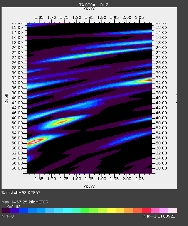
| Estimated Moho Depth: |
57.25 km |
| Estimated Crust Vp/Vs: |
1.63 |
| Assumed Crust Vp: |
6.483 km/s |
| Estimated Crust Vs: |
3.977 km/s |
| Estimated Crust Poisson's Ratio: |
0.20 |
|
| Radial Match: |
93.02857 % |
| Radial Bump: |
265 |
| Transverse Match: |
80.925 % |
| Transverse Bump: |
372 |
| SOD ConfigId: |
2760 |
| Insert Time: |
2010-03-06 01:45:44.048 +0000 |
| GWidth: |
2.5 |
| Max Bumps: |
400 |
| Tol: |
0.001 |
|

Signal To Noise
| Channel | StoN | STA | LTA |
| TA:R28A: :BHZ:20090510T01:23:10.025002Z | 17.18409 | 8.996885E-7 | 5.2355897E-8 |
| TA:R28A: :BHN:20090510T01:23:10.025002Z | 8.918889 | 6.2556563E-7 | 7.013941E-8 |
| TA:R28A: :BHE:20090510T01:23:10.025002Z | 3.3177438 | 2.4705835E-7 | 7.4465774E-8 |
| Arrivals |
| Ps | 6.0 SECOND |
| PpPs | 21 SECOND |
| PsPs/PpSs | 27 SECOND |


