You are here: Home > Network List > TA - USArray Transportable Network (new EarthScope stations) Stations List
> Station R28A Tribune, KS, USA > Earthquake Result Viewer
R28A Tribune, KS, USA - Earthquake Result Viewer
| Earthquake location: |
Tonga Islands |
| Earthquake latitude/longitude: |
-20.8/-174.3 |
| Earthquake time(UTC): |
2009/07/30 (211) 20:05:34 GMT |
| Earthquake Depth: |
10 km |
| Earthquake Magnitude: |
5.9 MB, 5.7 MS, 5.8 MW, 5.7 MW |
| Earthquake Catalog/Contributor: |
WHDF/NEIC |
|
| Network: |
TA USArray Transportable Network (new EarthScope stations) |
| Station: |
R28A Tribune, KS, USA |
| Lat/Lon: |
38.34 N/101.81 W |
| Elevation: |
1108 m |
|
| Distance: |
89.8 deg |
| Az: |
48.565 deg |
| Baz: |
243.094 deg |
| Ray Param: |
0.04171805 |
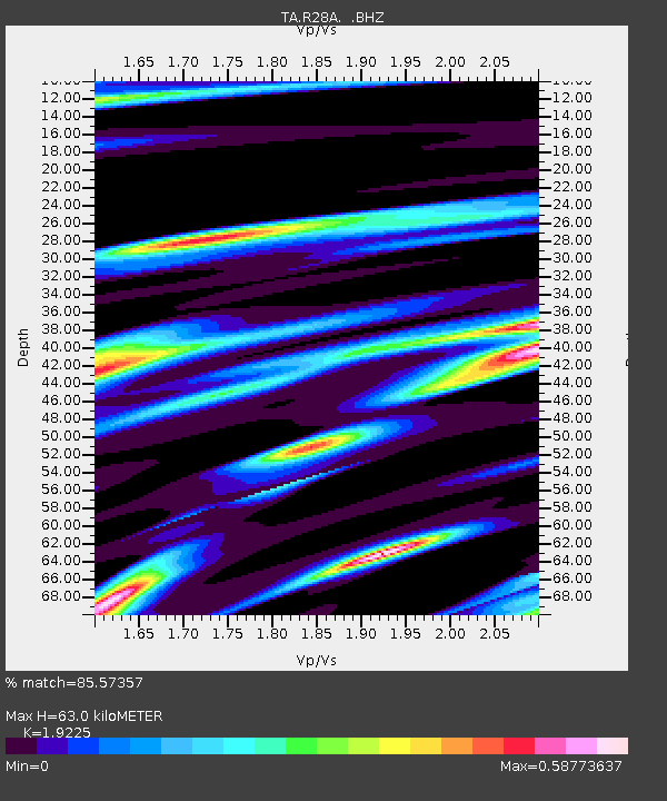
| Estimated Moho Depth: |
63.0 km |
| Estimated Crust Vp/Vs: |
1.92 |
| Assumed Crust Vp: |
6.483 km/s |
| Estimated Crust Vs: |
3.372 km/s |
| Estimated Crust Poisson's Ratio: |
0.31 |
|
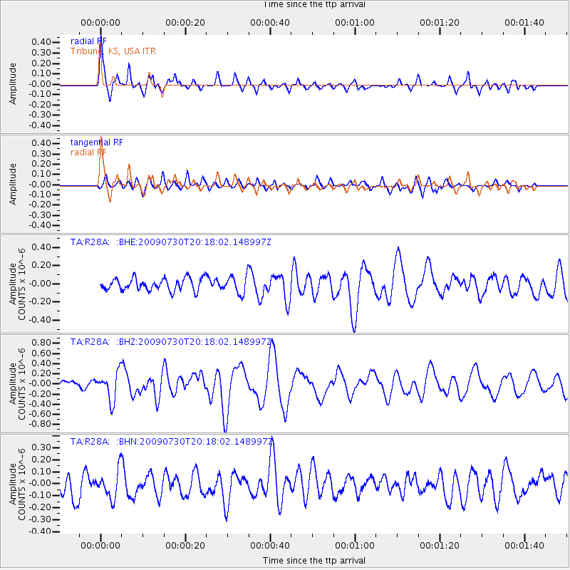
| Radial Match: |
85.57357 % |
| Radial Bump: |
378 |
| Transverse Match: |
56.488205 % |
| Transverse Bump: |
400 |
| SOD ConfigId: |
2622 |
| Insert Time: |
2010-03-06 01:45:45.185 +0000 |
| GWidth: |
2.5 |
| Max Bumps: |
400 |
| Tol: |
0.001 |
|
Signal To Noise
| Channel | StoN | STA | LTA |
| TA:R28A: :BHZ:20090730T20:18:02.148997Z | 3.63481 | 2.852543E-7 | 7.847846E-8 |
| TA:R28A: :BHN:20090730T20:18:02.148997Z | 1.1051613 | 1.225366E-7 | 1.1087667E-7 |
| TA:R28A: :BHE:20090730T20:18:02.148997Z | 1.5533053 | 1.026307E-7 | 6.607246E-8 |
| Arrivals |
| Ps | 9.1 SECOND |
| PpPs | 28 SECOND |
| PsPs/PpSs | 37 SECOND |


