You are here: Home > Network List > TA - USArray Transportable Network (new EarthScope stations) Stations List
> Station R28A Tribune, KS, USA > Earthquake Result Viewer
R28A Tribune, KS, USA - Earthquake Result Viewer
| Earthquake location: |
Northern Mid-Atlantic Ridge |
| Earthquake latitude/longitude: |
23.9/-46.1 |
| Earthquake time(UTC): |
2009/06/06 (157) 20:33:28 GMT |
| Earthquake Depth: |
14 km |
| Earthquake Magnitude: |
6.0 MB, 5.7 MS, 6.0 MW, 6.0 MW |
| Earthquake Catalog/Contributor: |
WHDF/NEIC |
|
| Network: |
TA USArray Transportable Network (new EarthScope stations) |
| Station: |
R28A Tribune, KS, USA |
| Lat/Lon: |
38.34 N/101.81 W |
| Elevation: |
1108 m |
|
| Distance: |
49.1 deg |
| Az: |
300.806 deg |
| Baz: |
90.177 deg |
| Ray Param: |
0.06887961 |
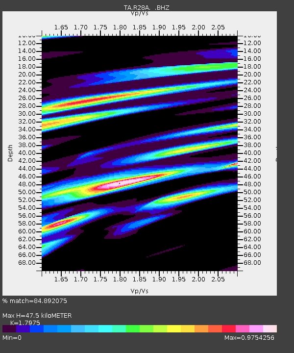
| Estimated Moho Depth: |
47.5 km |
| Estimated Crust Vp/Vs: |
1.80 |
| Assumed Crust Vp: |
6.483 km/s |
| Estimated Crust Vs: |
3.606 km/s |
| Estimated Crust Poisson's Ratio: |
0.28 |
|
| Radial Match: |
84.892075 % |
| Radial Bump: |
400 |
| Transverse Match: |
56.114494 % |
| Transverse Bump: |
400 |
| SOD ConfigId: |
2648 |
| Insert Time: |
2010-03-06 01:45:56.846 +0000 |
| GWidth: |
2.5 |
| Max Bumps: |
400 |
| Tol: |
0.001 |
|

Signal To Noise
| Channel | StoN | STA | LTA |
| TA:R28A: :BHZ:20090606T20:41:45.050001Z | 11.517513 | 6.360225E-7 | 5.522221E-8 |
| TA:R28A: :BHN:20090606T20:41:45.050001Z | 1.0414113 | 1.02389606E-7 | 9.8318125E-8 |
| TA:R28A: :BHE:20090606T20:41:45.050001Z | 3.890925 | 2.9305104E-7 | 7.531655E-8 |
| Arrivals |
| Ps | 6.2 SECOND |
| PpPs | 19 SECOND |
| PsPs/PpSs | 26 SECOND |


