You are here: Home > Network List > TA - USArray Transportable Network (new EarthScope stations) Stations List
> Station 121A Cookes Peak, Deming, NM, USA > Earthquake Result Viewer
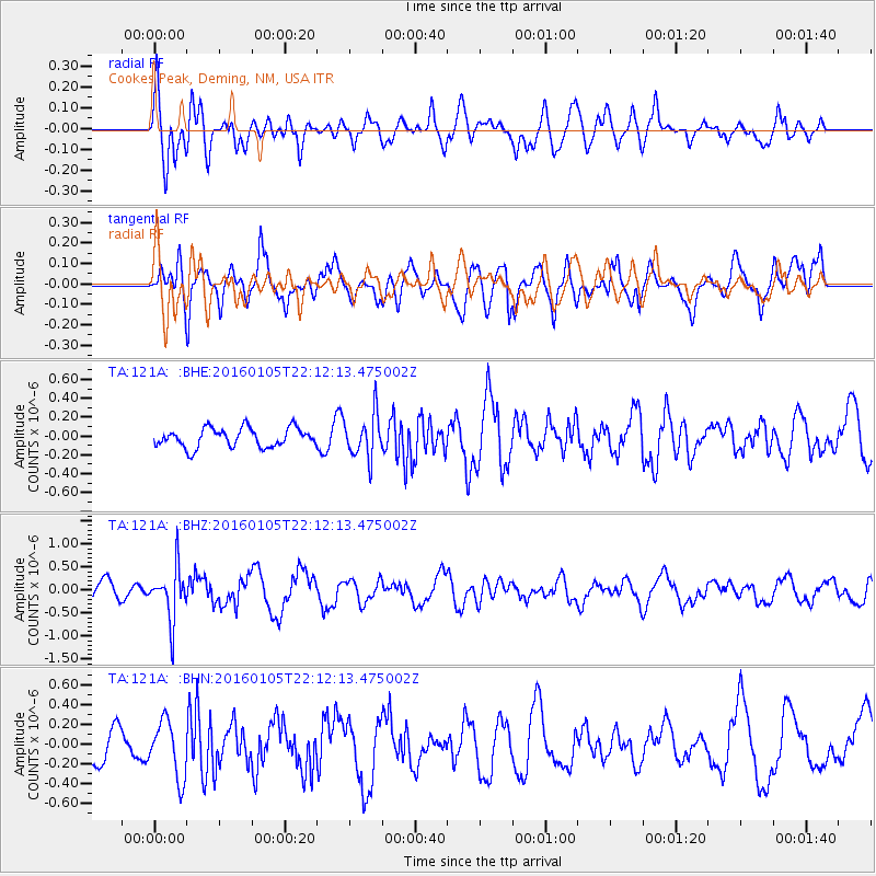
121A Cookes Peak, Deming, NM, USA - Earthquake Result Viewer
*The percent match for this event was below the threshold and hence no stack was calculated.
| Earthquake location: |
Volcano Islands, Japan Region |
| Earthquake latitude/longitude: |
22.0/143.7 |
| Earthquake time(UTC): |
2016/01/05 (005) 21:59:50 GMT |
| Earthquake Depth: |
158 km |
| Earthquake Magnitude: |
5.9 MB, 5.6 MWB |
| Earthquake Catalog/Contributor: |
NEIC PDE/NEIC COMCAT |
|
| Network: |
TA USArray Transportable Network (new EarthScope stations) |
| Station: |
121A Cookes Peak, Deming, NM, USA |
| Lat/Lon: |
32.53 N/107.79 W |
| Elevation: |
1652 m |
|
| Distance: |
92.8 deg |
| Az: |
53.307 deg |
| Baz: |
298.279 deg |
| Ray Param: |
$rayparam |
*The percent match for this event was below the threshold and hence was not used in the summary stack. |
|
| Radial Match: |
59.6111 % |
| Radial Bump: |
400 |
| Transverse Match: |
64.6036 % |
| Transverse Bump: |
400 |
| SOD ConfigId: |
1393891 |
| Insert Time: |
2016-01-19 22:42:06.920 +0000 |
| GWidth: |
2.5 |
| Max Bumps: |
400 |
| Tol: |
0.001 |
|
Signal To Noise
| Channel | StoN | STA | LTA |
| TA:121A: :BHZ:20160105T22:12:13.475002Z | 3.31345 | 5.682521E-7 | 1.7149863E-7 |
| TA:121A: :BHN:20160105T22:12:13.475002Z | 1.290158 | 2.874563E-7 | 2.2280705E-7 |
| TA:121A: :BHE:20160105T22:12:13.475002Z | 2.285331 | 2.2930155E-7 | 1.0033626E-7 |
| Arrivals |
| Ps | |
| PpPs | |
| PsPs/PpSs | |


