You are here: Home > Network List > TA - USArray Transportable Network (new EarthScope stations) Stations List
> Station R29A Marienthal, KS, USA > Earthquake Result Viewer
R29A Marienthal, KS, USA - Earthquake Result Viewer
| Earthquake location: |
Northern Mid-Atlantic Ridge |
| Earthquake latitude/longitude: |
23.9/-46.1 |
| Earthquake time(UTC): |
2009/06/06 (157) 20:33:28 GMT |
| Earthquake Depth: |
14 km |
| Earthquake Magnitude: |
6.0 MB, 5.7 MS, 6.0 MW, 6.0 MW |
| Earthquake Catalog/Contributor: |
WHDF/NEIC |
|
| Network: |
TA USArray Transportable Network (new EarthScope stations) |
| Station: |
R29A Marienthal, KS, USA |
| Lat/Lon: |
38.42 N/101.14 W |
| Elevation: |
957 m |
|
| Distance: |
48.6 deg |
| Az: |
300.92 deg |
| Baz: |
90.668 deg |
| Ray Param: |
0.06923258 |
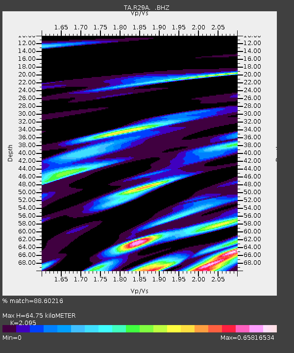
| Estimated Moho Depth: |
64.75 km |
| Estimated Crust Vp/Vs: |
2.10 |
| Assumed Crust Vp: |
6.483 km/s |
| Estimated Crust Vs: |
3.094 km/s |
| Estimated Crust Poisson's Ratio: |
0.35 |
|
| Radial Match: |
88.60216 % |
| Radial Bump: |
400 |
| Transverse Match: |
51.910755 % |
| Transverse Bump: |
400 |
| SOD ConfigId: |
2648 |
| Insert Time: |
2010-03-06 01:46:47.263 +0000 |
| GWidth: |
2.5 |
| Max Bumps: |
400 |
| Tol: |
0.001 |
|
Signal To Noise
| Channel | StoN | STA | LTA |
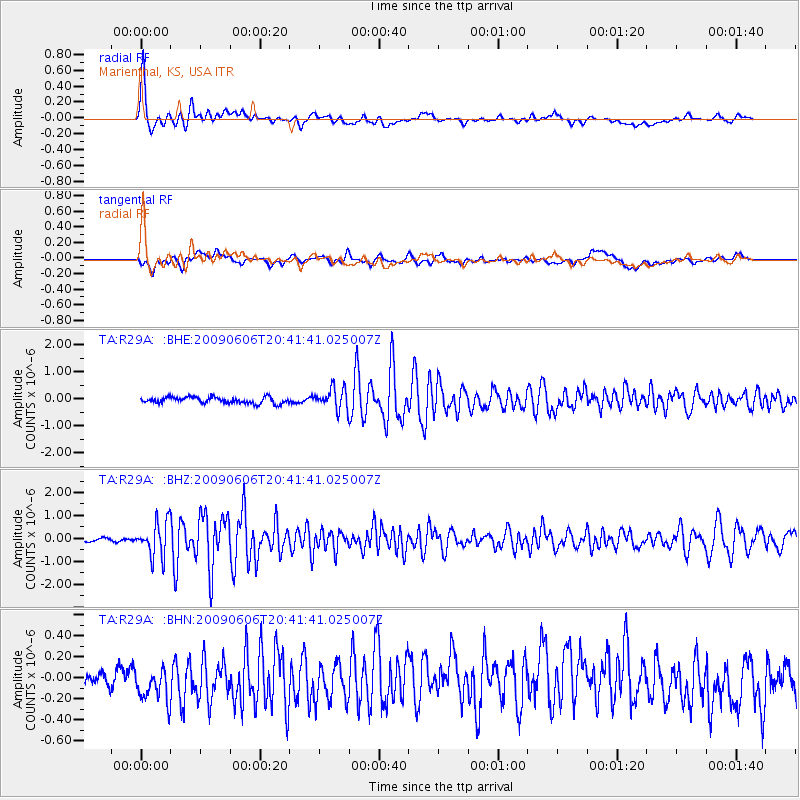
| TA:R29A: :BHZ:20090606T20:41:41.025007Z | 11.489963 | 7.580425E-7 | 6.5974326E-8 |
| TA:R29A: :BHN:20090606T20:41:41.025007Z | 1.8524033 | 2.3725075E-7 | 1.2807726E-7 |
| TA:R29A: :BHE:20090606T20:41:41.025007Z | 3.4404094 | 3.9587258E-7 | 1.1506554E-7 |
| Arrivals |
| Ps | 12 SECOND |
| PpPs | 29 SECOND |
| PsPs/PpSs | 41 SECOND |


