You are here: Home > Network List > RV - Regional Alberta Seismic Observatory for Earthquake Studies Network Stations List
> Station YELLA Yellowhead Lookout Tower, AB > Earthquake Result Viewer
YELLA Yellowhead Lookout Tower, AB - Earthquake Result Viewer
| Earthquake location: |
Sea Of Japan |
| Earthquake latitude/longitude: |
40.9/131.6 |
| Earthquake time(UTC): |
2017/07/12 (193) 19:48:07 GMT |
| Earthquake Depth: |
538 km |
| Earthquake Magnitude: |
5.8 Mww |
| Earthquake Catalog/Contributor: |
NEIC PDE/us |
|
| Network: |
RV Regional Alberta Seismic Observatory for Earthquake Studies Network |
| Station: |
YELLA Yellowhead Lookout Tower, AB |
| Lat/Lon: |
53.24 N/117.14 W |
| Elevation: |
1478 m |
|
| Distance: |
69.2 deg |
| Az: |
36.836 deg |
| Baz: |
310.839 deg |
| Ray Param: |
0.053987067 |
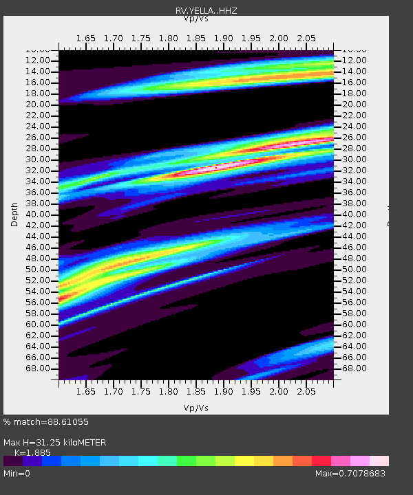
| Estimated Moho Depth: |
31.25 km |
| Estimated Crust Vp/Vs: |
1.88 |
| Assumed Crust Vp: |
6.142 km/s |
| Estimated Crust Vs: |
3.258 km/s |
| Estimated Crust Poisson's Ratio: |
0.30 |
|
| Radial Match: |
88.61055 % |
| Radial Bump: |
341 |
| Transverse Match: |
46.623703 % |
| Transverse Bump: |
400 |
| SOD ConfigId: |
13570011 |
| Insert Time: |
2019-04-28 09:08:38.224 +0000 |
| GWidth: |
2.5 |
| Max Bumps: |
400 |
| Tol: |
0.001 |
|

Signal To Noise
| Channel | StoN | STA | LTA |
| RV:YELLA: :HHZ:20170712T19:57:48.75999Z | 10.6994505 | 1.5710137E-6 | 1.4683125E-7 |
| RV:YELLA: :HHN:20170712T19:57:48.75999Z | 4.4312263 | 8.5238656E-7 | 1.9235908E-7 |
| RV:YELLA: :HHE:20170712T19:57:48.75999Z | 3.607094 | 8.412758E-7 | 2.3322812E-7 |
| Arrivals |
| Ps | 4.6 SECOND |
| PpPs | 14 SECOND |
| PsPs/PpSs | 19 SECOND |


