You are here: Home > Network List > TA - USArray Transportable Network (new EarthScope stations) Stations List
> Station C24K Franklin Bluffs, AK, USA > Earthquake Result Viewer
C24K Franklin Bluffs, AK, USA - Earthquake Result Viewer
| Earthquake location: |
Sea Of Japan |
| Earthquake latitude/longitude: |
40.9/131.6 |
| Earthquake time(UTC): |
2017/07/12 (193) 19:48:07 GMT |
| Earthquake Depth: |
538 km |
| Earthquake Magnitude: |
5.8 Mww |
| Earthquake Catalog/Contributor: |
NEIC PDE/us |
|
| Network: |
TA USArray Transportable Network (new EarthScope stations) |
| Station: |
C24K Franklin Bluffs, AK, USA |
| Lat/Lon: |
69.72 N/148.70 W |
| Elevation: |
115 m |
|
| Distance: |
48.8 deg |
| Az: |
27.105 deg |
| Baz: |
277.608 deg |
| Ray Param: |
0.06663701 |
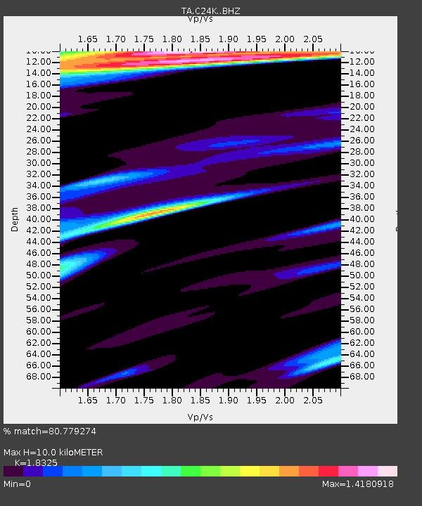
| Estimated Moho Depth: |
10.0 km |
| Estimated Crust Vp/Vs: |
1.83 |
| Assumed Crust Vp: |
6.316 km/s |
| Estimated Crust Vs: |
3.447 km/s |
| Estimated Crust Poisson's Ratio: |
0.29 |
|
| Radial Match: |
80.779274 % |
| Radial Bump: |
400 |
| Transverse Match: |
71.19218 % |
| Transverse Bump: |
400 |
| SOD ConfigId: |
13570011 |
| Insert Time: |
2019-04-28 09:09:01.116 +0000 |
| GWidth: |
2.5 |
| Max Bumps: |
400 |
| Tol: |
0.001 |
|

Signal To Noise
| Channel | StoN | STA | LTA |
| TA:C24K: :BHZ:20170712T19:55:32.924999Z | 27.063164 | 3.7077E-6 | 1.3700172E-7 |
| TA:C24K: :BHN:20170712T19:55:32.924999Z | 3.075048 | 3.7775783E-7 | 1.2284616E-7 |
| TA:C24K: :BHE:20170712T19:55:32.924999Z | 7.7620425 | 1.0252521E-6 | 1.3208535E-7 |
| Arrivals |
| Ps | 1.4 SECOND |
| PpPs | 4.3 SECOND |
| PsPs/PpSs | 5.6 SECOND |


