You are here: Home > Network List > TA - USArray Transportable Network (new EarthScope stations) Stations List
> Station D23K Nanushuk River, AK USA > Earthquake Result Viewer
D23K Nanushuk River, AK USA - Earthquake Result Viewer
| Earthquake location: |
Sea Of Japan |
| Earthquake latitude/longitude: |
40.9/131.6 |
| Earthquake time(UTC): |
2017/07/12 (193) 19:48:07 GMT |
| Earthquake Depth: |
538 km |
| Earthquake Magnitude: |
5.8 Mww |
| Earthquake Catalog/Contributor: |
NEIC PDE/us |
|
| Network: |
TA USArray Transportable Network (new EarthScope stations) |
| Station: |
D23K Nanushuk River, AK USA |
| Lat/Lon: |
68.97 N/150.68 W |
| Elevation: |
406 m |
|
| Distance: |
48.2 deg |
| Az: |
28.224 deg |
| Baz: |
276.498 deg |
| Ray Param: |
0.06700329 |
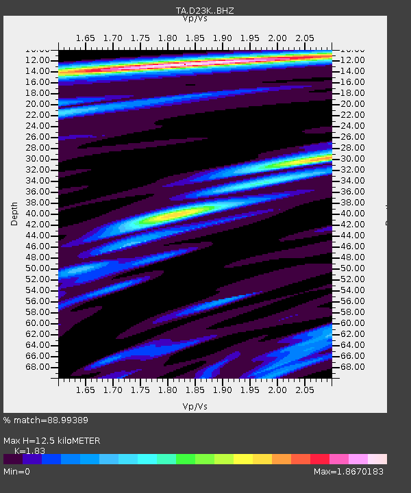
| Estimated Moho Depth: |
12.5 km |
| Estimated Crust Vp/Vs: |
1.83 |
| Assumed Crust Vp: |
6.221 km/s |
| Estimated Crust Vs: |
3.399 km/s |
| Estimated Crust Poisson's Ratio: |
0.29 |
|
| Radial Match: |
88.99389 % |
| Radial Bump: |
400 |
| Transverse Match: |
84.36853 % |
| Transverse Bump: |
400 |
| SOD ConfigId: |
13570011 |
| Insert Time: |
2019-04-28 09:09:02.683 +0000 |
| GWidth: |
2.5 |
| Max Bumps: |
400 |
| Tol: |
0.001 |
|

Signal To Noise
| Channel | StoN | STA | LTA |
| TA:D23K: :BHZ:20170712T19:55:28.449993Z | 41.36122 | 3.0981416E-6 | 7.49045E-8 |
| TA:D23K: :BHN:20170712T19:55:28.449993Z | 3.8096018 | 2.4761027E-7 | 6.499637E-8 |
| TA:D23K: :BHE:20170712T19:55:28.449993Z | 26.551334 | 1.1962118E-6 | 4.5052793E-8 |
| Arrivals |
| Ps | 1.8 SECOND |
| PpPs | 5.4 SECOND |
| PsPs/PpSs | 7.2 SECOND |


