You are here: Home > Network List > TA - USArray Transportable Network (new EarthScope stations) Stations List
> Station G22K Bettles, AK, USA > Earthquake Result Viewer
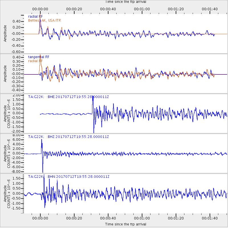
G22K Bettles, AK, USA - Earthquake Result Viewer
*The percent match for this event was below the threshold and hence no stack was calculated.
| Earthquake location: |
Sea Of Japan |
| Earthquake latitude/longitude: |
40.9/131.6 |
| Earthquake time(UTC): |
2017/07/12 (193) 19:48:07 GMT |
| Earthquake Depth: |
538 km |
| Earthquake Magnitude: |
5.8 Mww |
| Earthquake Catalog/Contributor: |
NEIC PDE/us |
|
| Network: |
TA USArray Transportable Network (new EarthScope stations) |
| Station: |
G22K Bettles, AK, USA |
| Lat/Lon: |
66.92 N/151.51 W |
| Elevation: |
205 m |
|
| Distance: |
48.2 deg |
| Az: |
31.01 deg |
| Baz: |
277.589 deg |
| Ray Param: |
$rayparam |
*The percent match for this event was below the threshold and hence was not used in the summary stack. |
|
| Radial Match: |
78.98782 % |
| Radial Bump: |
400 |
| Transverse Match: |
81.78173 % |
| Transverse Bump: |
400 |
| SOD ConfigId: |
13570011 |
| Insert Time: |
2019-04-28 09:09:16.698 +0000 |
| GWidth: |
2.5 |
| Max Bumps: |
400 |
| Tol: |
0.001 |
|
Signal To Noise
| Channel | StoN | STA | LTA |
| TA:G22K: :BHZ:20170712T19:55:28.000011Z | 38.92007 | 2.2790575E-6 | 5.8557386E-8 |
| TA:G22K: :BHN:20170712T19:55:28.000011Z | 9.853538 | 5.531344E-7 | 5.6135615E-8 |
| TA:G22K: :BHE:20170712T19:55:28.000011Z | 22.72481 | 8.1221395E-7 | 3.5741287E-8 |
| Arrivals |
| Ps | |
| PpPs | |
| PsPs/PpSs | |


