You are here: Home > Network List > TA - USArray Transportable Network (new EarthScope stations) Stations List
> Station H19K Roundabout Mountain, AK, USA > Earthquake Result Viewer
H19K Roundabout Mountain, AK, USA - Earthquake Result Viewer
| Earthquake location: |
Sea Of Japan |
| Earthquake latitude/longitude: |
40.9/131.6 |
| Earthquake time(UTC): |
2017/07/12 (193) 19:48:07 GMT |
| Earthquake Depth: |
538 km |
| Earthquake Magnitude: |
5.8 Mww |
| Earthquake Catalog/Contributor: |
NEIC PDE/us |
|
| Network: |
TA USArray Transportable Network (new EarthScope stations) |
| Station: |
H19K Roundabout Mountain, AK, USA |
| Lat/Lon: |
65.53 N/156.45 W |
| Elevation: |
107 m |
|
| Distance: |
46.3 deg |
| Az: |
33.192 deg |
| Baz: |
274.552 deg |
| Ray Param: |
0.06817046 |
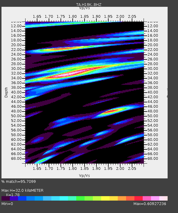
| Estimated Moho Depth: |
32.0 km |
| Estimated Crust Vp/Vs: |
1.78 |
| Assumed Crust Vp: |
6.182 km/s |
| Estimated Crust Vs: |
3.473 km/s |
| Estimated Crust Poisson's Ratio: |
0.27 |
|
| Radial Match: |
95.7099 % |
| Radial Bump: |
394 |
| Transverse Match: |
92.24951 % |
| Transverse Bump: |
400 |
| SOD ConfigId: |
13570011 |
| Insert Time: |
2019-04-28 09:09:23.834 +0000 |
| GWidth: |
2.5 |
| Max Bumps: |
400 |
| Tol: |
0.001 |
|

Signal To Noise
| Channel | StoN | STA | LTA |
| TA:H19K: :BHZ:20170712T19:55:14.174999Z | 82.91989 | 3.6120864E-6 | 4.356116E-8 |
| TA:H19K: :BHN:20170712T19:55:14.174999Z | 16.12262 | 7.255429E-7 | 4.5001553E-8 |
| TA:H19K: :BHE:20170712T19:55:14.174999Z | 45.58292 | 1.6956302E-6 | 3.7198806E-8 |
| Arrivals |
| Ps | 4.3 SECOND |
| PpPs | 14 SECOND |
| PsPs/PpSs | 18 SECOND |


