You are here: Home > Network List > TA - USArray Transportable Network (new EarthScope stations) Stations List
> Station K17K Iditarod, AK, USA > Earthquake Result Viewer
K17K Iditarod, AK, USA - Earthquake Result Viewer
| Earthquake location: |
Sea Of Japan |
| Earthquake latitude/longitude: |
40.9/131.6 |
| Earthquake time(UTC): |
2017/07/12 (193) 19:48:07 GMT |
| Earthquake Depth: |
538 km |
| Earthquake Magnitude: |
5.8 Mww |
| Earthquake Catalog/Contributor: |
NEIC PDE/us |
|
| Network: |
TA USArray Transportable Network (new EarthScope stations) |
| Station: |
K17K Iditarod, AK, USA |
| Lat/Lon: |
62.72 N/158.30 W |
| Elevation: |
339 m |
|
| Distance: |
45.8 deg |
| Az: |
37.199 deg |
| Baz: |
275.669 deg |
| Ray Param: |
0.06850585 |
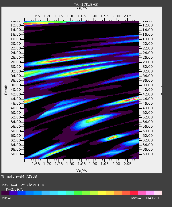
| Estimated Moho Depth: |
43.25 km |
| Estimated Crust Vp/Vs: |
2.10 |
| Assumed Crust Vp: |
6.276 km/s |
| Estimated Crust Vs: |
2.992 km/s |
| Estimated Crust Poisson's Ratio: |
0.35 |
|
| Radial Match: |
84.72368 % |
| Radial Bump: |
400 |
| Transverse Match: |
80.27031 % |
| Transverse Bump: |
400 |
| SOD ConfigId: |
13570011 |
| Insert Time: |
2019-04-28 09:09:43.553 +0000 |
| GWidth: |
2.5 |
| Max Bumps: |
400 |
| Tol: |
0.001 |
|

Signal To Noise
| Channel | StoN | STA | LTA |
| TA:K17K: :BHZ:20170712T19:55:09.949993Z | 47.147903 | 2.4315632E-6 | 5.1573092E-8 |
| TA:K17K: :BHN:20170712T19:55:09.949993Z | 3.829356 | 2.6755208E-7 | 6.986869E-8 |
| TA:K17K: :BHE:20170712T19:55:09.949993Z | 15.7194 | 1.0860907E-6 | 6.909237E-8 |
| Arrivals |
| Ps | 7.9 SECOND |
| PpPs | 20 SECOND |
| PsPs/PpSs | 28 SECOND |


