You are here: Home > Network List > TA - USArray Transportable Network (new EarthScope stations) Stations List
> Station L15K Ungalak Mountain, AK, USA > Earthquake Result Viewer
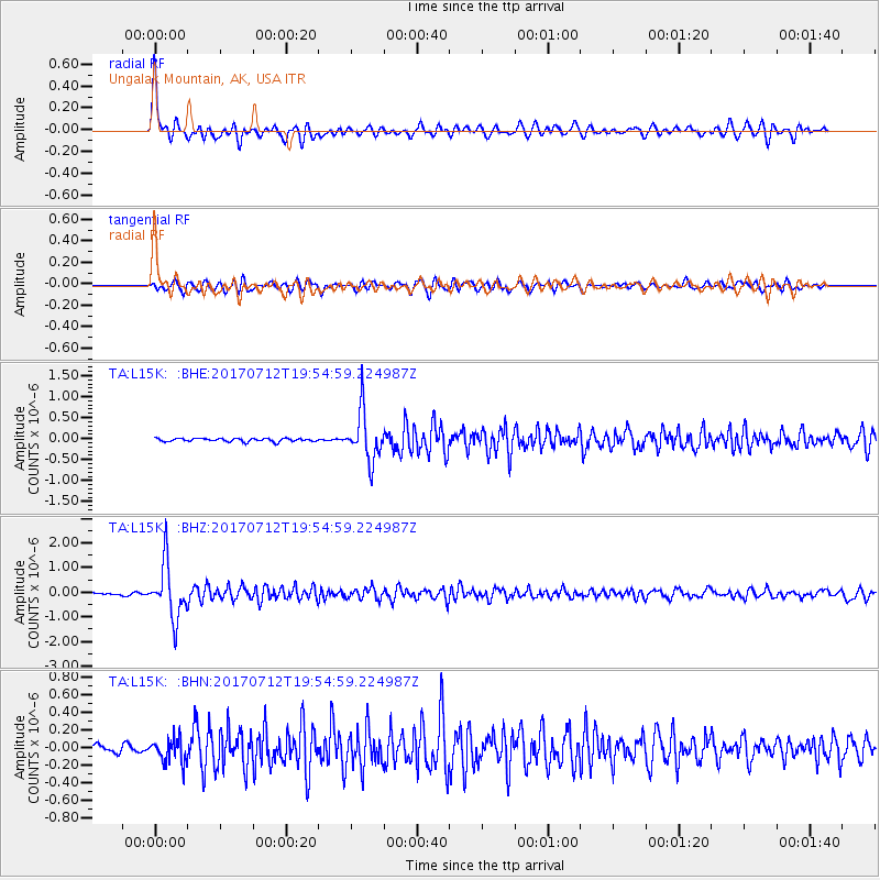
L15K Ungalak Mountain, AK, USA - Earthquake Result Viewer
*The percent match for this event was below the threshold and hence no stack was calculated.
| Earthquake location: |
Sea Of Japan |
| Earthquake latitude/longitude: |
40.9/131.6 |
| Earthquake time(UTC): |
2017/07/12 (193) 19:48:07 GMT |
| Earthquake Depth: |
538 km |
| Earthquake Magnitude: |
5.8 Mww |
| Earthquake Catalog/Contributor: |
NEIC PDE/us |
|
| Network: |
TA USArray Transportable Network (new EarthScope stations) |
| Station: |
L15K Ungalak Mountain, AK, USA |
| Lat/Lon: |
61.68 N/161.49 W |
| Elevation: |
219 m |
|
| Distance: |
44.4 deg |
| Az: |
38.843 deg |
| Baz: |
274.016 deg |
| Ray Param: |
$rayparam |
*The percent match for this event was below the threshold and hence was not used in the summary stack. |
|
| Radial Match: |
75.71438 % |
| Radial Bump: |
400 |
| Transverse Match: |
53.239178 % |
| Transverse Bump: |
400 |
| SOD ConfigId: |
13570011 |
| Insert Time: |
2019-04-28 09:09:50.114 +0000 |
| GWidth: |
2.5 |
| Max Bumps: |
400 |
| Tol: |
0.001 |
|
Signal To Noise
| Channel | StoN | STA | LTA |
| TA:L15K: :BHZ:20170712T19:54:59.224987Z | 23.067152 | 1.0911832E-6 | 4.7304635E-8 |
| TA:L15K: :BHN:20170712T19:54:59.224987Z | 2.606048 | 1.368016E-7 | 5.249389E-8 |
| TA:L15K: :BHE:20170712T19:54:59.224987Z | 15.244959 | 5.771778E-7 | 3.786024E-8 |
| Arrivals |
| Ps | |
| PpPs | |
| PsPs/PpSs | |


