You are here: Home > Network List > TA - USArray Transportable Network (new EarthScope stations) Stations List
> Station L29M Grand Valley Creek, YT, CAN > Earthquake Result Viewer
L29M Grand Valley Creek, YT, CAN - Earthquake Result Viewer
| Earthquake location: |
Sea Of Japan |
| Earthquake latitude/longitude: |
40.9/131.6 |
| Earthquake time(UTC): |
2017/07/12 (193) 19:48:07 GMT |
| Earthquake Depth: |
538 km |
| Earthquake Magnitude: |
5.8 Mww |
| Earthquake Catalog/Contributor: |
NEIC PDE/us |
|
| Network: |
TA USArray Transportable Network (new EarthScope stations) |
| Station: |
L29M Grand Valley Creek, YT, CAN |
| Lat/Lon: |
63.11 N/138.13 W |
| Elevation: |
918 m |
|
| Distance: |
54.6 deg |
| Az: |
33.896 deg |
| Baz: |
291.521 deg |
| Ray Param: |
0.06306558 |
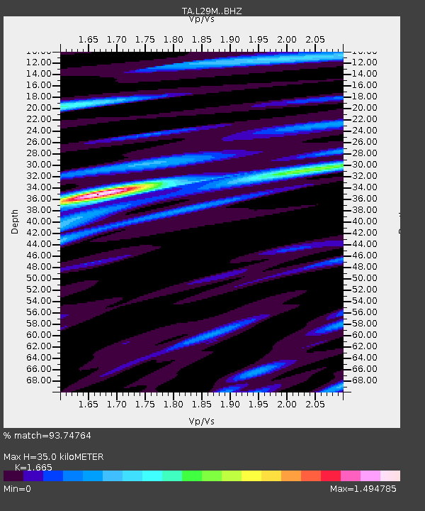
| Estimated Moho Depth: |
35.0 km |
| Estimated Crust Vp/Vs: |
1.66 |
| Assumed Crust Vp: |
6.566 km/s |
| Estimated Crust Vs: |
3.944 km/s |
| Estimated Crust Poisson's Ratio: |
0.22 |
|
| Radial Match: |
93.74764 % |
| Radial Bump: |
400 |
| Transverse Match: |
86.819176 % |
| Transverse Bump: |
400 |
| SOD ConfigId: |
13570011 |
| Insert Time: |
2019-04-28 09:09:56.047 +0000 |
| GWidth: |
2.5 |
| Max Bumps: |
400 |
| Tol: |
0.001 |
|
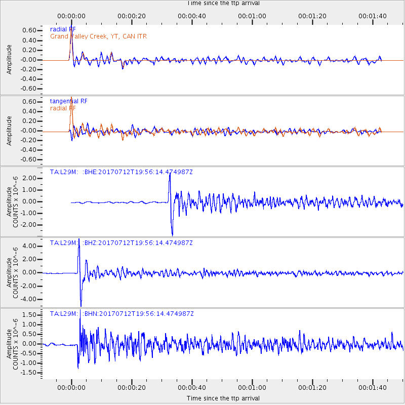
Signal To Noise
| Channel | StoN | STA | LTA |
| TA:L29M: :BHZ:20170712T19:56:14.474987Z | 77.67655 | 1.983499E-6 | 2.5535366E-8 |
| TA:L29M: :BHN:20170712T19:56:14.474987Z | 12.182875 | 4.8758494E-7 | 4.0022158E-8 |
| TA:L29M: :BHE:20170712T19:56:14.474987Z | 26.171318 | 1.1104803E-6 | 4.2431196E-8 |
| Arrivals |
| Ps | 3.7 SECOND |
| PpPs | 13 SECOND |
| PsPs/PpSs | 17 SECOND |


