You are here: Home > Network List > TA - USArray Transportable Network (new EarthScope stations) Stations List
> Station O20A White River City, CO, USA > Earthquake Result Viewer
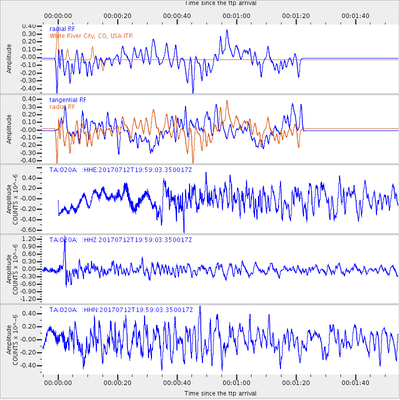
O20A White River City, CO, USA - Earthquake Result Viewer
*The percent match for this event was below the threshold and hence no stack was calculated.
| Earthquake location: |
Sea Of Japan |
| Earthquake latitude/longitude: |
40.9/131.6 |
| Earthquake time(UTC): |
2017/07/12 (193) 19:48:07 GMT |
| Earthquake Depth: |
538 km |
| Earthquake Magnitude: |
5.8 Mww |
| Earthquake Catalog/Contributor: |
NEIC PDE/us |
|
| Network: |
TA USArray Transportable Network (new EarthScope stations) |
| Station: |
O20A White River City, CO, USA |
| Lat/Lon: |
40.13 N/108.24 W |
| Elevation: |
1915 m |
|
| Distance: |
82.7 deg |
| Az: |
41.95 deg |
| Baz: |
318.594 deg |
| Ray Param: |
$rayparam |
*The percent match for this event was below the threshold and hence was not used in the summary stack. |
|
| Radial Match: |
45.938675 % |
| Radial Bump: |
400 |
| Transverse Match: |
52.94099 % |
| Transverse Bump: |
400 |
| SOD ConfigId: |
13570011 |
| Insert Time: |
2019-04-28 09:10:23.492 +0000 |
| GWidth: |
2.5 |
| Max Bumps: |
400 |
| Tol: |
0.001 |
|
Signal To Noise
| Channel | StoN | STA | LTA |
| TA:O20A: :HHZ:20170712T19:59:03.350017Z | 4.974069 | 4.1224155E-7 | 8.2878124E-8 |
| TA:O20A: :HHN:20170712T19:59:03.350017Z | 0.61397105 | 8.488351E-8 | 1.3825327E-7 |
| TA:O20A: :HHE:20170712T19:59:03.350017Z | 1.3565636 | 1.9800349E-7 | 1.459596E-7 |
| Arrivals |
| Ps | |
| PpPs | |
| PsPs/PpSs | |


