You are here: Home > Network List > TA - USArray Transportable Network (new EarthScope stations) Stations List
> Station R32K Eaglecrest, AK, USA > Earthquake Result Viewer
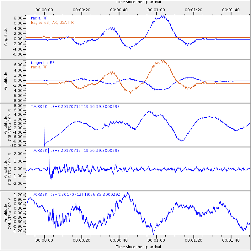
R32K Eaglecrest, AK, USA - Earthquake Result Viewer
*The percent match for this event was below the threshold and hence no stack was calculated.
| Earthquake location: |
Sea Of Japan |
| Earthquake latitude/longitude: |
40.9/131.6 |
| Earthquake time(UTC): |
2017/07/12 (193) 19:48:07 GMT |
| Earthquake Depth: |
538 km |
| Earthquake Magnitude: |
5.8 Mww |
| Earthquake Catalog/Contributor: |
NEIC PDE/us |
|
| Network: |
TA USArray Transportable Network (new EarthScope stations) |
| Station: |
R32K Eaglecrest, AK, USA |
| Lat/Lon: |
58.27 N/134.52 W |
| Elevation: |
386 m |
|
| Distance: |
58.2 deg |
| Az: |
38.32 deg |
| Baz: |
297.117 deg |
| Ray Param: |
$rayparam |
*The percent match for this event was below the threshold and hence was not used in the summary stack. |
|
| Radial Match: |
40.582664 % |
| Radial Bump: |
400 |
| Transverse Match: |
33.17387 % |
| Transverse Bump: |
400 |
| SOD ConfigId: |
13570011 |
| Insert Time: |
2019-04-28 09:10:43.774 +0000 |
| GWidth: |
2.5 |
| Max Bumps: |
400 |
| Tol: |
0.001 |
|
Signal To Noise
| Channel | StoN | STA | LTA |
| TA:R32K: :BHZ:20170712T19:56:39.300029Z | 9.951311 | 9.3205483E-7 | 9.3661505E-8 |
| TA:R32K: :BHN:20170712T19:56:39.300029Z | 0.8847379 | 3.798187E-7 | 4.2930077E-7 |
| TA:R32K: :BHE:20170712T19:56:39.300029Z | 0.43239912 | 1.4380353E-6 | 3.3257127E-6 |
| Arrivals |
| Ps | |
| PpPs | |
| PsPs/PpSs | |


