You are here: Home > Network List > TA - USArray Transportable Network (new EarthScope stations) Stations List
> Station S31A Mullinville, KS, USA > Earthquake Result Viewer
S31A Mullinville, KS, USA - Earthquake Result Viewer
| Earthquake location: |
East Of Severnaya Zemlya |
| Earthquake latitude/longitude: |
81.6/119.5 |
| Earthquake time(UTC): |
2009/10/07 (280) 20:52:13 GMT |
| Earthquake Depth: |
8.0 km |
| Earthquake Magnitude: |
5.7 MB, 5.1 MS, 5.8 MW, 5.8 MW |
| Earthquake Catalog/Contributor: |
WHDF/NEIC |
|
| Network: |
TA USArray Transportable Network (new EarthScope stations) |
| Station: |
S31A Mullinville, KS, USA |
| Lat/Lon: |
37.62 N/99.48 W |
| Elevation: |
700 m |
|
| Distance: |
59.3 deg |
| Az: |
35.538 deg |
| Baz: |
353.8 deg |
| Ray Param: |
0.062267803 |
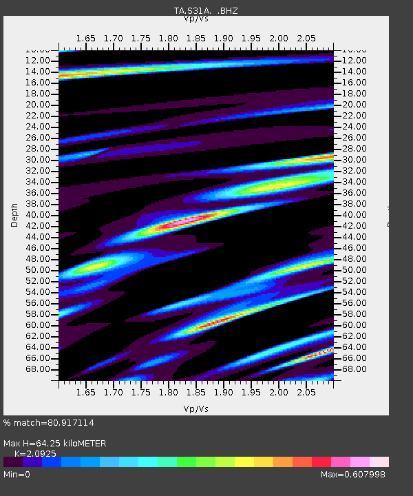
| Estimated Moho Depth: |
64.25 km |
| Estimated Crust Vp/Vs: |
2.09 |
| Assumed Crust Vp: |
6.426 km/s |
| Estimated Crust Vs: |
3.071 km/s |
| Estimated Crust Poisson's Ratio: |
0.35 |
|
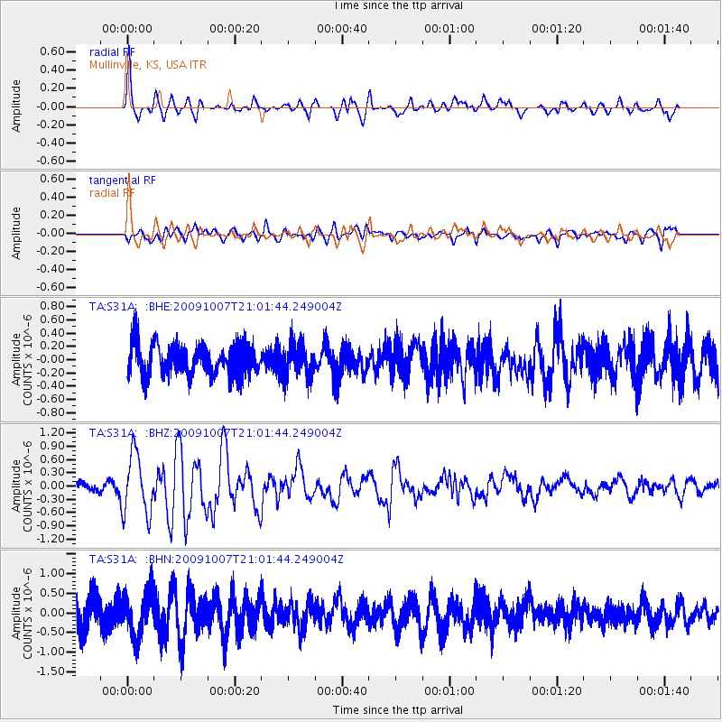
| Radial Match: |
80.917114 % |
| Radial Bump: |
400 |
| Transverse Match: |
70.465805 % |
| Transverse Bump: |
400 |
| SOD ConfigId: |
2622 |
| Insert Time: |
2010-03-06 01:47:34.967 +0000 |
| GWidth: |
2.5 |
| Max Bumps: |
400 |
| Tol: |
0.001 |
|
Signal To Noise
| Channel | StoN | STA | LTA |
| TA:S31A: :BHZ:20091007T21:01:44.249004Z | 6.2106543 | 6.8694334E-7 | 1.1060724E-7 |
| TA:S31A: :BHN:20091007T21:01:44.249004Z | 1.7442199 | 5.7266095E-7 | 3.2831923E-7 |
| TA:S31A: :BHE:20091007T21:01:44.249004Z | 1.0859075 | 2.566139E-7 | 2.3631289E-7 |
| Arrivals |
| Ps | 11 SECOND |
| PpPs | 30 SECOND |
| PsPs/PpSs | 41 SECOND |


