You are here: Home > Network List > UW - Pacific Northwest Regional Seismic Network Stations List
> Station HEBO Mt. Hebo, OR CREST BB SMO > Earthquake Result Viewer
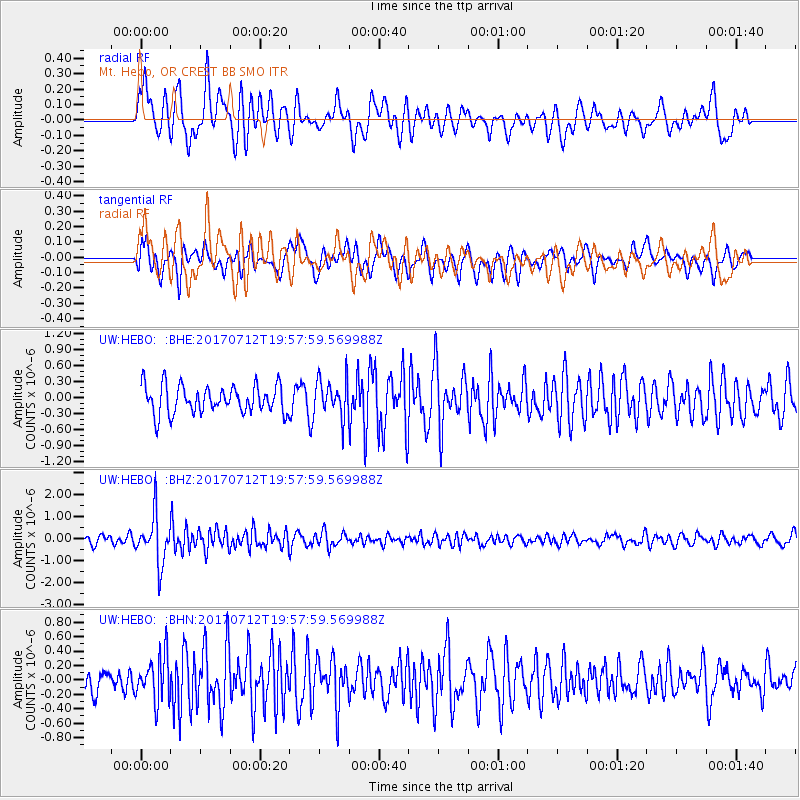
HEBO Mt. Hebo, OR CREST BB SMO - Earthquake Result Viewer
*The percent match for this event was below the threshold and hence no stack was calculated.
| Earthquake location: |
Sea Of Japan |
| Earthquake latitude/longitude: |
40.9/131.6 |
| Earthquake time(UTC): |
2017/07/12 (193) 19:48:07 GMT |
| Earthquake Depth: |
538 km |
| Earthquake Magnitude: |
5.8 Mww |
| Earthquake Catalog/Contributor: |
NEIC PDE/us |
|
| Network: |
UW Pacific Northwest Regional Seismic Network |
| Station: |
HEBO Mt. Hebo, OR CREST BB SMO |
| Lat/Lon: |
45.21 N/123.76 W |
| Elevation: |
875 m |
|
| Distance: |
71.0 deg |
| Az: |
46.339 deg |
| Baz: |
309.075 deg |
| Ray Param: |
$rayparam |
*The percent match for this event was below the threshold and hence was not used in the summary stack. |
|
| Radial Match: |
69.07434 % |
| Radial Bump: |
400 |
| Transverse Match: |
60.994392 % |
| Transverse Bump: |
400 |
| SOD ConfigId: |
13570011 |
| Insert Time: |
2019-04-28 09:11:46.597 +0000 |
| GWidth: |
2.5 |
| Max Bumps: |
400 |
| Tol: |
0.001 |
|
Signal To Noise
| Channel | StoN | STA | LTA |
| UW:HEBO: :BHZ:20170712T19:57:59.569988Z | 7.324264 | 1.0963963E-6 | 1.4969373E-7 |
| UW:HEBO: :BHN:20170712T19:57:59.569988Z | 2.2089756 | 3.12704E-7 | 1.4156065E-7 |
| UW:HEBO: :BHE:20170712T19:57:59.569988Z | 1.3535037 | 3.534583E-7 | 2.611432E-7 |
| Arrivals |
| Ps | |
| PpPs | |
| PsPs/PpSs | |


