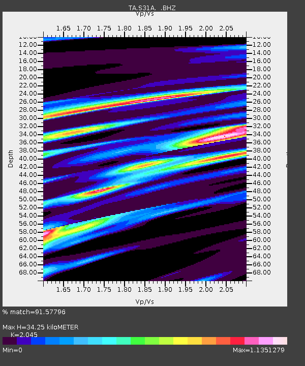
S31A Mullinville, KS, USA - Earthquake Result Viewer

Earthquake location: Rat Islands, Aleutian Islands
Earthquake latitude/longitude: 50.4/177.0
Earthquake time(UTC): 2009/07/06 (187) 14:53:12 GMT
Earthquake Depth: 22 km
Earthquake Magnitude: 6.0 MB, 5.8 MS, 6.1 MW, 6.0 MW
Earthquake Catalog/Contributor: WHDF/NEIC
Network: TA USArray Transportable Network (new EarthScope stations)
Station: S31A Mullinville, KS, USA
Lat/Lon: 37.62 N/99.48 W
Elevation: 700 m
Distance: 58.4 deg
Az: 67.933 deg
Baz: 311.725 deg
Ray Param: 0.06286697
Estimated Moho Depth: 34.25 km
Estimated Crust Vp/Vs: 2.05
Assumed Crust Vp: 6.426 km/s
Estimated Crust Vs: 3.142 km/s
Estimated Crust Poisson's Ratio: 0.34
Radial Match: 91.57796 %
Radial Bump: 400
Transverse Match: 73.64256 %
Transverse Bump: 400
SOD ConfigId: 2648
Insert Time: 2010-03-06 01:47:42.461 +0000
GWidth: 2.5
Max Bumps: 400
Tol: 0.001

Signal To Noise

ChannelStoNSTALTA
TA:S31A: :BHZ:20090706T15:02:34.724009Z7.0832131.8505646E-62.6126062E-7
TA:S31A: :BHN:20090706T15:02:34.724009Z2.94582587.445832E-72.5275872E-7
TA:S31A: :BHE:20090706T15:02:34.724009Z5.41414749.080888E-71.6772518E-7
Arrivals
Ps5.8 SECOND
PpPs16 SECOND
PsPs/PpSs21 SECOND