You are here: Home > Network List > TA - USArray Transportable Network (new EarthScope stations) Stations List
> Station S31A Mullinville, KS, USA > Earthquake Result Viewer
S31A Mullinville, KS, USA - Earthquake Result Viewer
| Earthquake location: |
Southern Peru |
| Earthquake latitude/longitude: |
-15.0/-70.4 |
| Earthquake time(UTC): |
2009/07/12 (193) 06:12:47 GMT |
| Earthquake Depth: |
199 km |
| Earthquake Magnitude: |
5.7 MB, 6.1 MW, 6.1 MW |
| Earthquake Catalog/Contributor: |
WHDF/NEIC |
|
| Network: |
TA USArray Transportable Network (new EarthScope stations) |
| Station: |
S31A Mullinville, KS, USA |
| Lat/Lon: |
37.62 N/99.48 W |
| Elevation: |
700 m |
|
| Distance: |
59.1 deg |
| Az: |
333.298 deg |
| Baz: |
146.856 deg |
| Ray Param: |
0.061784755 |
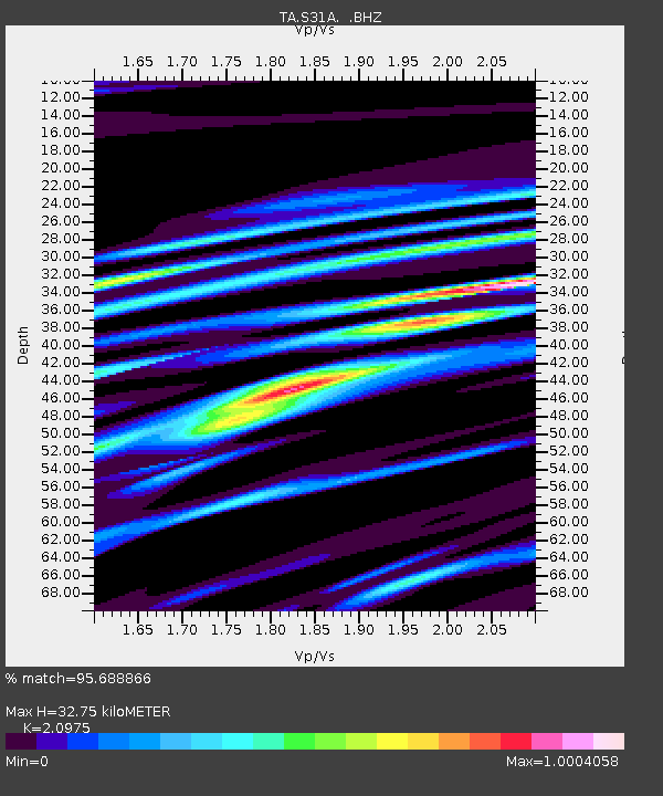
| Estimated Moho Depth: |
32.75 km |
| Estimated Crust Vp/Vs: |
2.10 |
| Assumed Crust Vp: |
6.426 km/s |
| Estimated Crust Vs: |
3.064 km/s |
| Estimated Crust Poisson's Ratio: |
0.35 |
|
| Radial Match: |
95.688866 % |
| Radial Bump: |
357 |
| Transverse Match: |
83.995255 % |
| Transverse Bump: |
373 |
| SOD ConfigId: |
2648 |
| Insert Time: |
2010-03-06 01:47:45.352 +0000 |
| GWidth: |
2.5 |
| Max Bumps: |
400 |
| Tol: |
0.001 |
|
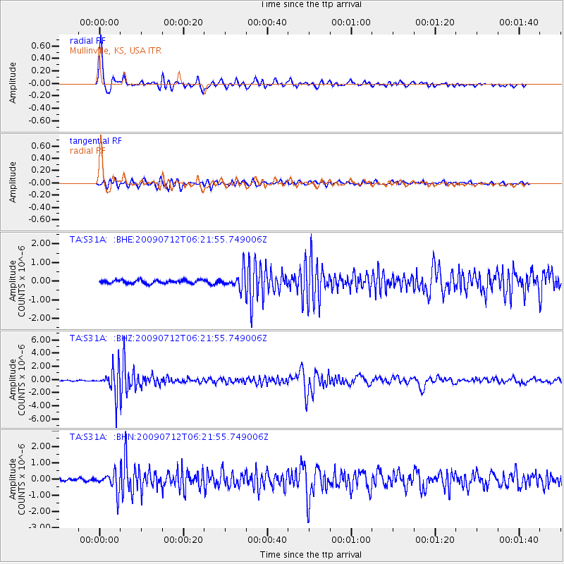
Signal To Noise
| Channel | StoN | STA | LTA |
| TA:S31A: :BHZ:20090712T06:21:55.749006Z | 31.055346 | 2.027962E-6 | 6.530155E-8 |
| TA:S31A: :BHN:20090712T06:21:55.749006Z | 6.3948216 | 5.90668E-7 | 9.236661E-8 |
| TA:S31A: :BHE:20090712T06:21:55.749006Z | 5.2791443 | 4.6636677E-7 | 8.834135E-8 |
| Arrivals |
| Ps | 5.8 SECOND |
| PpPs | 15 SECOND |
| PsPs/PpSs | 21 SECOND |


