You are here: Home > Network List > TA - USArray Transportable Network (new EarthScope stations) Stations List
> Station S31A Mullinville, KS, USA > Earthquake Result Viewer
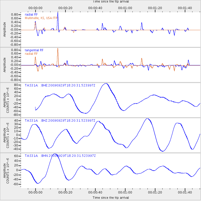
S31A Mullinville, KS, USA - Earthquake Result Viewer
*The percent match for this event was below the threshold and hence no stack was calculated.
| Earthquake location: |
Samoa Islands Region |
| Earthquake latitude/longitude: |
-15.6/-172.0 |
| Earthquake time(UTC): |
2009/09/29 (272) 18:08:21 GMT |
| Earthquake Depth: |
10 km |
| Earthquake Magnitude: |
5.6 MB |
| Earthquake Catalog/Contributor: |
WHDF/NEIC |
|
| Network: |
TA USArray Transportable Network (new EarthScope stations) |
| Station: |
S31A Mullinville, KS, USA |
| Lat/Lon: |
37.62 N/99.48 W |
| Elevation: |
700 m |
|
| Distance: |
86.1 deg |
| Az: |
49.392 deg |
| Baz: |
247.145 deg |
| Ray Param: |
$rayparam |
*The percent match for this event was below the threshold and hence was not used in the summary stack. |
|
| Radial Match: |
31.847954 % |
| Radial Bump: |
197 |
| Transverse Match: |
29.163652 % |
| Transverse Bump: |
268 |
| SOD ConfigId: |
2622 |
| Insert Time: |
2010-03-06 01:47:54.592 +0000 |
| GWidth: |
2.5 |
| Max Bumps: |
400 |
| Tol: |
0.001 |
|
Signal To Noise
| Channel | StoN | STA | LTA |
| TA:S31A: :BHZ:20090929T18:20:31.523997Z | 2.707719 | 2.4623707E-5 | 9.093893E-6 |
| TA:S31A: :BHN:20090929T18:20:31.523997Z | 3.0743077 | 5.1558873E-5 | 1.677089E-5 |
| TA:S31A: :BHE:20090929T18:20:31.523997Z | 3.1730247 | 7.7751E-5 | 2.4503748E-5 |
| Arrivals |
| Ps | |
| PpPs | |
| PsPs/PpSs | |


