You are here: Home > Network List > AK - Alaska Regional Network Stations List
> Station CHN Chernabura Island, AK, USA > Earthquake Result Viewer
CHN Chernabura Island, AK, USA - Earthquake Result Viewer
| Earthquake location: |
New Ireland Region, P.N.G. |
| Earthquake latitude/longitude: |
-4.8/153.2 |
| Earthquake time(UTC): |
2017/07/13 (194) 03:36:09 GMT |
| Earthquake Depth: |
47 km |
| Earthquake Magnitude: |
6.4 mww |
| Earthquake Catalog/Contributor: |
NEIC PDE/us |
|
| Network: |
AK Alaska Regional Network |
| Station: |
CHN Chernabura Island, AK, USA |
| Lat/Lon: |
54.83 N/159.59 W |
| Elevation: |
71 m |
|
| Distance: |
71.1 deg |
| Az: |
26.683 deg |
| Baz: |
230.666 deg |
| Ray Param: |
0.054454356 |
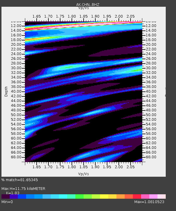
| Estimated Moho Depth: |
11.75 km |
| Estimated Crust Vp/Vs: |
1.83 |
| Assumed Crust Vp: |
5.989 km/s |
| Estimated Crust Vs: |
3.273 km/s |
| Estimated Crust Poisson's Ratio: |
0.29 |
|
| Radial Match: |
81.65345 % |
| Radial Bump: |
400 |
| Transverse Match: |
72.860435 % |
| Transverse Bump: |
400 |
| SOD ConfigId: |
13570011 |
| Insert Time: |
2019-04-28 09:13:49.165 +0000 |
| GWidth: |
2.5 |
| Max Bumps: |
400 |
| Tol: |
0.001 |
|

Signal To Noise
| Channel | StoN | STA | LTA |
| AK:CHN: :BHZ:20170713T03:46:52.568008Z | 14.892917 | 1.7377705E-6 | 1.1668436E-7 |
| AK:CHN: :BHN:20170713T03:46:52.568008Z | 3.1891818 | 4.888512E-7 | 1.532842E-7 |
| AK:CHN: :BHE:20170713T03:46:52.568008Z | 4.0571475 | 7.0462994E-7 | 1.736762E-7 |
| Arrivals |
| Ps | 1.7 SECOND |
| PpPs | 5.4 SECOND |
| PsPs/PpSs | 7.1 SECOND |


