You are here: Home > Network List > AK - Alaska Regional Network Stations List
> Station FALS False Pass > Earthquake Result Viewer
FALS False Pass - Earthquake Result Viewer
| Earthquake location: |
New Ireland Region, P.N.G. |
| Earthquake latitude/longitude: |
-4.8/153.2 |
| Earthquake time(UTC): |
2017/07/13 (194) 03:36:09 GMT |
| Earthquake Depth: |
47 km |
| Earthquake Magnitude: |
6.4 mww |
| Earthquake Catalog/Contributor: |
NEIC PDE/us |
|
| Network: |
AK Alaska Regional Network |
| Station: |
FALS False Pass |
| Lat/Lon: |
54.86 N/163.42 W |
| Elevation: |
46 m |
|
| Distance: |
69.5 deg |
| Az: |
25.115 deg |
| Baz: |
227.015 deg |
| Ray Param: |
0.055540103 |
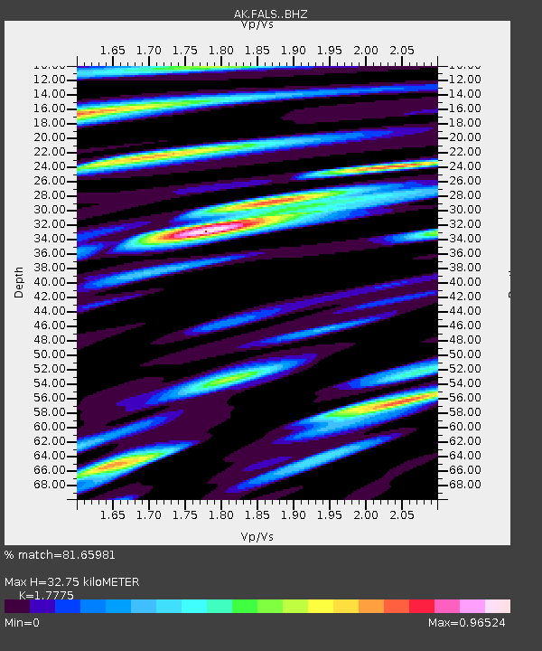
| Estimated Moho Depth: |
32.75 km |
| Estimated Crust Vp/Vs: |
1.78 |
| Assumed Crust Vp: |
5.989 km/s |
| Estimated Crust Vs: |
3.369 km/s |
| Estimated Crust Poisson's Ratio: |
0.27 |
|
| Radial Match: |
81.65981 % |
| Radial Bump: |
400 |
| Transverse Match: |
79.252556 % |
| Transverse Bump: |
400 |
| SOD ConfigId: |
13570011 |
| Insert Time: |
2019-04-28 09:13:57.026 +0000 |
| GWidth: |
2.5 |
| Max Bumps: |
400 |
| Tol: |
0.001 |
|

Signal To Noise
| Channel | StoN | STA | LTA |
| AK:FALS: :BHZ:20170713T03:46:42.50801Z | 14.532441 | 1.7281748E-6 | 1.18918415E-7 |
| AK:FALS: :BHN:20170713T03:46:42.50801Z | 5.883736 | 2.402364E-6 | 4.0830588E-7 |
| AK:FALS: :BHE:20170713T03:46:42.50801Z | 2.3853214 | 8.86192E-7 | 3.7151892E-7 |
| Arrivals |
| Ps | 4.4 SECOND |
| PpPs | 15 SECOND |
| PsPs/PpSs | 19 SECOND |


