You are here: Home > Network List > TA - USArray Transportable Network (new EarthScope stations) Stations List
> Station R30A Dighton, KS, USA > Earthquake Result Viewer
R30A Dighton, KS, USA - Earthquake Result Viewer
| Earthquake location: |
Samoa Islands Region |
| Earthquake latitude/longitude: |
-15.2/-172.6 |
| Earthquake time(UTC): |
2009/08/30 (242) 14:51:32 GMT |
| Earthquake Depth: |
11 km |
| Earthquake Magnitude: |
6.4 MB, 6.3 MS, 6.6 MW, 6.6 MW |
| Earthquake Catalog/Contributor: |
WHDF/NEIC |
|
| Network: |
TA USArray Transportable Network (new EarthScope stations) |
| Station: |
R30A Dighton, KS, USA |
| Lat/Lon: |
38.28 N/100.28 W |
| Elevation: |
776 m |
|
| Distance: |
86.0 deg |
| Az: |
48.723 deg |
| Baz: |
247.204 deg |
| Ray Param: |
0.044372983 |
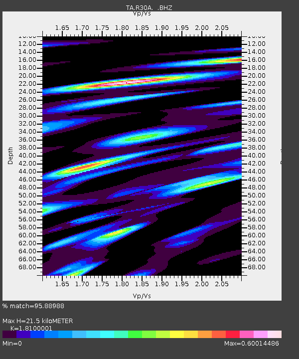
| Estimated Moho Depth: |
21.5 km |
| Estimated Crust Vp/Vs: |
1.81 |
| Assumed Crust Vp: |
6.483 km/s |
| Estimated Crust Vs: |
3.582 km/s |
| Estimated Crust Poisson's Ratio: |
0.28 |
|
| Radial Match: |
95.88988 % |
| Radial Bump: |
373 |
| Transverse Match: |
81.93599 % |
| Transverse Bump: |
400 |
| SOD ConfigId: |
2622 |
| Insert Time: |
2010-03-06 01:48:12.902 +0000 |
| GWidth: |
2.5 |
| Max Bumps: |
400 |
| Tol: |
0.001 |
|
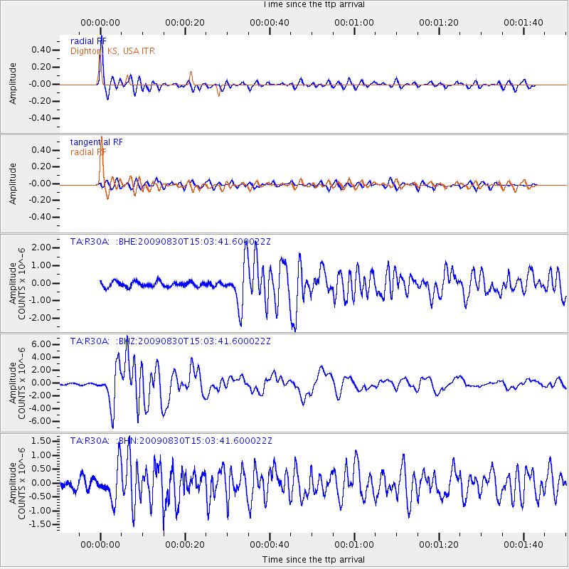
Signal To Noise
| Channel | StoN | STA | LTA |
| TA:R30A: :BHZ:20090830T15:03:41.600022Z | 23.795382 | 2.9952075E-6 | 1.2587348E-7 |
| TA:R30A: :BHN:20090830T15:03:41.600022Z | 4.636608 | 6.2023986E-7 | 1.3377017E-7 |
| TA:R30A: :BHE:20090830T15:03:41.600022Z | 8.416396 | 1.257883E-6 | 1.4945624E-7 |
| Arrivals |
| Ps | 2.8 SECOND |
| PpPs | 9.1 SECOND |
| PsPs/PpSs | 12 SECOND |


