You are here: Home > Network List > TA - USArray Transportable Network (new EarthScope stations) Stations List
> Station R30A Dighton, KS, USA > Earthquake Result Viewer
R30A Dighton, KS, USA - Earthquake Result Viewer
| Earthquake location: |
Near Coast Of Venezuela |
| Earthquake latitude/longitude: |
10.7/-67.9 |
| Earthquake time(UTC): |
2009/09/12 (255) 20:06:24 GMT |
| Earthquake Depth: |
10 km |
| Earthquake Magnitude: |
6.3 MB, 6.4 MS, 6.3 MW, 6.3 MW |
| Earthquake Catalog/Contributor: |
WHDF/NEIC |
|
| Network: |
TA USArray Transportable Network (new EarthScope stations) |
| Station: |
R30A Dighton, KS, USA |
| Lat/Lon: |
38.28 N/100.28 W |
| Elevation: |
776 m |
|
| Distance: |
39.9 deg |
| Az: |
318.954 deg |
| Baz: |
124.905 deg |
| Ray Param: |
0.07471513 |
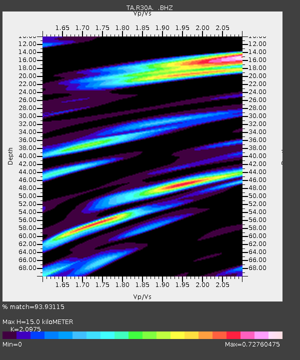
| Estimated Moho Depth: |
15.0 km |
| Estimated Crust Vp/Vs: |
2.10 |
| Assumed Crust Vp: |
6.483 km/s |
| Estimated Crust Vs: |
3.091 km/s |
| Estimated Crust Poisson's Ratio: |
0.35 |
|
| Radial Match: |
93.93115 % |
| Radial Bump: |
280 |
| Transverse Match: |
62.175537 % |
| Transverse Bump: |
400 |
| SOD ConfigId: |
2622 |
| Insert Time: |
2010-03-06 01:48:15.736 +0000 |
| GWidth: |
2.5 |
| Max Bumps: |
400 |
| Tol: |
0.001 |
|
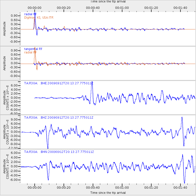
Signal To Noise
| Channel | StoN | STA | LTA |
| TA:R30A: :BHZ:20090912T20:13:27.775011Z | 8.411441 | 1.0200772E-6 | 1.2127259E-7 |
| TA:R30A: :BHN:20090912T20:13:27.775011Z | 3.807449 | 4.7246104E-7 | 1.240886E-7 |
| TA:R30A: :BHE:20090912T20:13:27.775011Z | 4.448518 | 5.647387E-7 | 1.2694984E-7 |
| Arrivals |
| Ps | 2.7 SECOND |
| PpPs | 6.7 SECOND |
| PsPs/PpSs | 9.4 SECOND |


