You are here: Home > Network List > TA - USArray Transportable Network (new EarthScope stations) Stations List
> Station R30A Dighton, KS, USA > Earthquake Result Viewer
R30A Dighton, KS, USA - Earthquake Result Viewer
| Earthquake location: |
Samoa Islands Region |
| Earthquake latitude/longitude: |
-15.5/-172.1 |
| Earthquake time(UTC): |
2009/09/29 (272) 17:48:10 GMT |
| Earthquake Depth: |
18 km |
| Earthquake Magnitude: |
7.1 MB, 8.1 MS, 8.1 MW, 8.0 MW |
| Earthquake Catalog/Contributor: |
WHDF/NEIC |
|
| Network: |
TA USArray Transportable Network (new EarthScope stations) |
| Station: |
R30A Dighton, KS, USA |
| Lat/Lon: |
38.28 N/100.28 W |
| Elevation: |
776 m |
|
| Distance: |
85.8 deg |
| Az: |
48.562 deg |
| Baz: |
246.701 deg |
| Ray Param: |
0.04448156 |
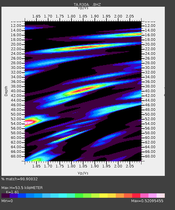
| Estimated Moho Depth: |
53.5 km |
| Estimated Crust Vp/Vs: |
1.61 |
| Assumed Crust Vp: |
6.483 km/s |
| Estimated Crust Vs: |
4.026 km/s |
| Estimated Crust Poisson's Ratio: |
0.19 |
|
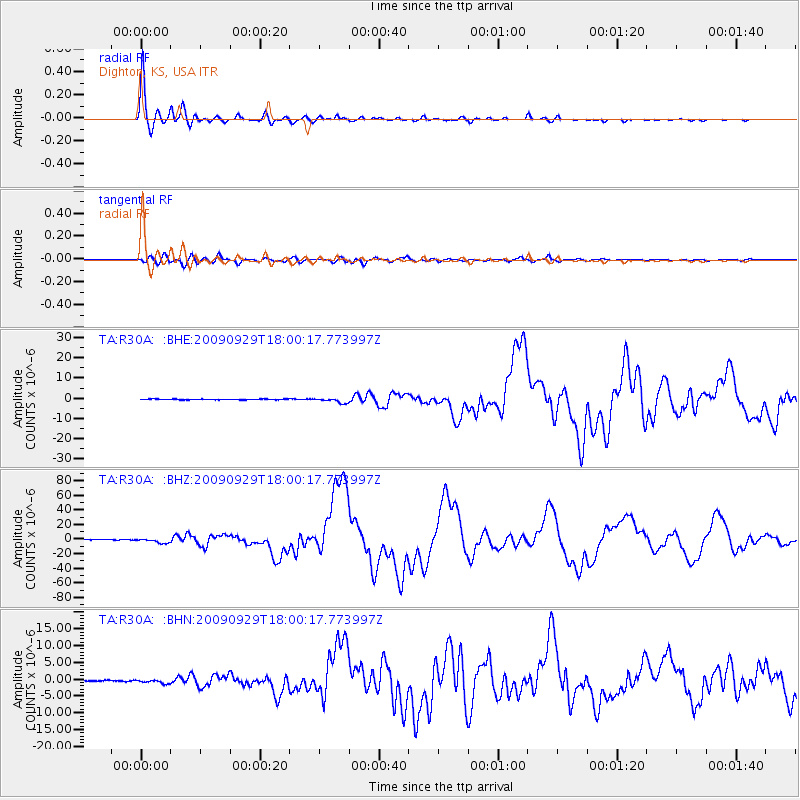
| Radial Match: |
98.90832 % |
| Radial Bump: |
390 |
| Transverse Match: |
92.73032 % |
| Transverse Bump: |
400 |
| SOD ConfigId: |
2622 |
| Insert Time: |
2010-03-06 01:48:17.289 +0000 |
| GWidth: |
2.5 |
| Max Bumps: |
400 |
| Tol: |
0.001 |
|
Signal To Noise
| Channel | StoN | STA | LTA |
| TA:R30A: :BHZ:20090929T18:00:17.773997Z | 13.289588 | 2.895473E-6 | 2.178753E-7 |
| TA:R30A: :BHN:20090929T18:00:17.773997Z | 3.3797903 | 5.8900935E-7 | 1.7427394E-7 |
| TA:R30A: :BHE:20090929T18:00:17.773997Z | 6.5312066 | 1.176046E-6 | 1.8006565E-7 |
| Arrivals |
| Ps | 5.2 SECOND |
| PpPs | 21 SECOND |
| PsPs/PpSs | 26 SECOND |


