You are here: Home > Network List > TA - USArray Transportable Network (new EarthScope stations) Stations List
> Station R30A Dighton, KS, USA > Earthquake Result Viewer
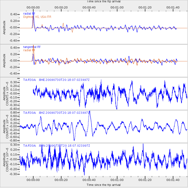
R30A Dighton, KS, USA - Earthquake Result Viewer
*The percent match for this event was below the threshold and hence no stack was calculated.
| Earthquake location: |
Tonga Islands |
| Earthquake latitude/longitude: |
-20.8/-174.3 |
| Earthquake time(UTC): |
2009/07/30 (211) 20:05:34 GMT |
| Earthquake Depth: |
10 km |
| Earthquake Magnitude: |
5.9 MB, 5.7 MS, 5.8 MW, 5.7 MW |
| Earthquake Catalog/Contributor: |
WHDF/NEIC |
|
| Network: |
TA USArray Transportable Network (new EarthScope stations) |
| Station: |
R30A Dighton, KS, USA |
| Lat/Lon: |
38.28 N/100.28 W |
| Elevation: |
776 m |
|
| Distance: |
90.9 deg |
| Az: |
49.154 deg |
| Baz: |
244.038 deg |
| Ray Param: |
$rayparam |
*The percent match for this event was below the threshold and hence was not used in the summary stack. |
|
| Radial Match: |
75.94248 % |
| Radial Bump: |
400 |
| Transverse Match: |
47.958797 % |
| Transverse Bump: |
400 |
| SOD ConfigId: |
2622 |
| Insert Time: |
2010-03-06 01:48:27.160 +0000 |
| GWidth: |
2.5 |
| Max Bumps: |
400 |
| Tol: |
0.001 |
|
Signal To Noise
| Channel | StoN | STA | LTA |
| TA:R30A: :BHZ:20090730T20:18:07.023997Z | 3.4412293 | 1.9833719E-7 | 5.7635564E-8 |
| TA:R30A: :BHN:20090730T20:18:07.023997Z | 0.5484825 | 4.8003646E-8 | 8.752084E-8 |
| TA:R30A: :BHE:20090730T20:18:07.023997Z | 1.7298715 | 1.3515772E-7 | 7.8131656E-8 |
| Arrivals |
| Ps | |
| PpPs | |
| PsPs/PpSs | |


