You are here: Home > Network List > AU - Australian Seismological Centre Stations List
> Station XMIS Christmas Island Grants Well > Earthquake Result Viewer
XMIS Christmas Island Grants Well - Earthquake Result Viewer
| Earthquake location: |
New Ireland Region, P.N.G. |
| Earthquake latitude/longitude: |
-4.8/153.2 |
| Earthquake time(UTC): |
2017/07/13 (194) 03:36:09 GMT |
| Earthquake Depth: |
47 km |
| Earthquake Magnitude: |
6.4 mww |
| Earthquake Catalog/Contributor: |
NEIC PDE/us |
|
| Network: |
AU Australian Seismological Centre |
| Station: |
XMIS Christmas Island Grants Well |
| Lat/Lon: |
10.48 S/105.65 E |
| Elevation: |
210 m |
|
| Distance: |
47.4 deg |
| Az: |
260.219 deg |
| Baz: |
86.876 deg |
| Ray Param: |
0.069904424 |
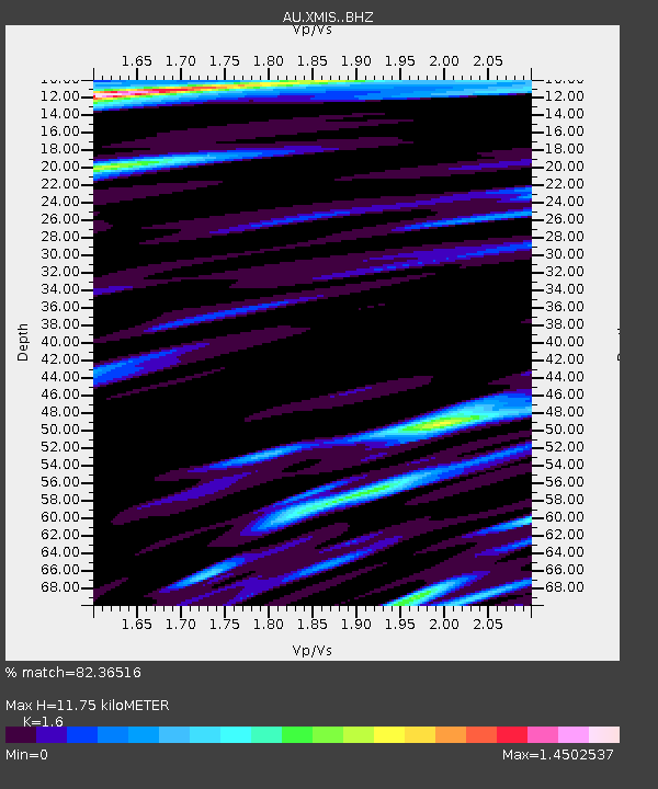
| Estimated Moho Depth: |
11.75 km |
| Estimated Crust Vp/Vs: |
1.60 |
| Assumed Crust Vp: |
4.157 km/s |
| Estimated Crust Vs: |
2.598 km/s |
| Estimated Crust Poisson's Ratio: |
0.18 |
|
| Radial Match: |
82.36516 % |
| Radial Bump: |
400 |
| Transverse Match: |
74.43881 % |
| Transverse Bump: |
400 |
| SOD ConfigId: |
13570011 |
| Insert Time: |
2019-04-28 09:15:03.161 +0000 |
| GWidth: |
2.5 |
| Max Bumps: |
400 |
| Tol: |
0.001 |
|

Signal To Noise
| Channel | StoN | STA | LTA |
| AU:XMIS: :BHZ:20170713T03:44:09.369003Z | 2.511397 | 1.4497878E-6 | 5.772834E-7 |
| AU:XMIS: :BHN:20170713T03:44:09.369003Z | 0.8354879 | 6.4263236E-7 | 7.6917013E-7 |
| AU:XMIS: :BHE:20170713T03:44:09.369003Z | 1.8437126 | 1.1821191E-6 | 6.411624E-7 |
| Arrivals |
| Ps | 1.7 SECOND |
| PpPs | 7.2 SECOND |
| PsPs/PpSs | 8.9 SECOND |


