You are here: Home > Network List > AV - Alaska Volcano Observatory Stations List
> Station AMKA Regional Station, Amchitka Island, Alaska > Earthquake Result Viewer
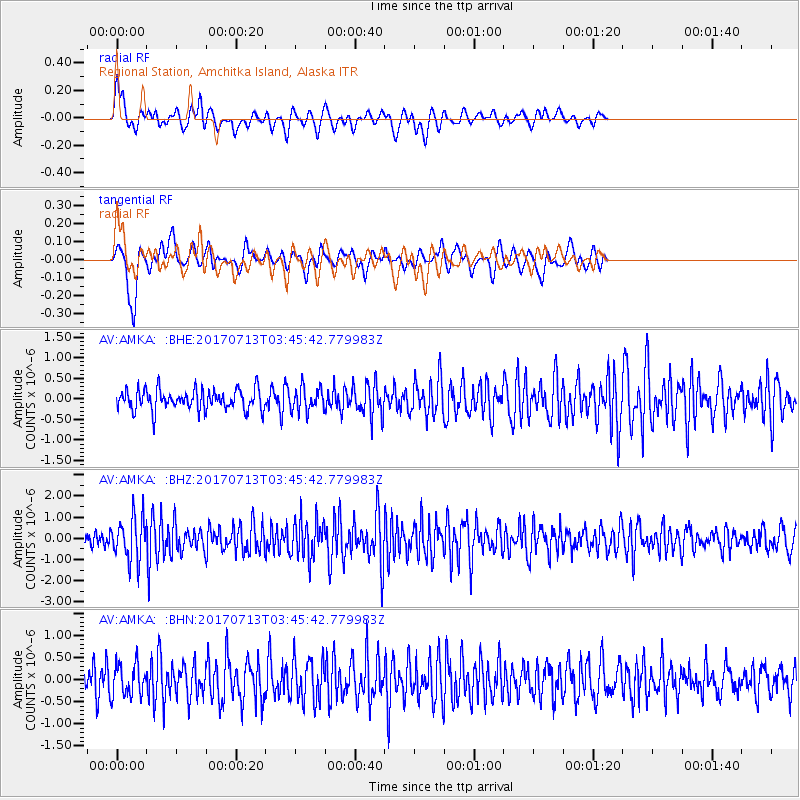
AMKA Regional Station, Amchitka Island, Alaska - Earthquake Result Viewer
*The percent match for this event was below the threshold and hence no stack was calculated.
| Earthquake location: |
New Ireland Region, P.N.G. |
| Earthquake latitude/longitude: |
-4.8/153.2 |
| Earthquake time(UTC): |
2017/07/13 (194) 03:36:09 GMT |
| Earthquake Depth: |
47 km |
| Earthquake Magnitude: |
6.4 mww |
| Earthquake Catalog/Contributor: |
NEIC PDE/us |
|
| Network: |
AV Alaska Volcano Observatory |
| Station: |
AMKA Regional Station, Amchitka Island, Alaska |
| Lat/Lon: |
51.38 N/179.30 E |
| Elevation: |
116 m |
|
| Distance: |
60.3 deg |
| Az: |
18.544 deg |
| Baz: |
210.378 deg |
| Ray Param: |
$rayparam |
*The percent match for this event was below the threshold and hence was not used in the summary stack. |
|
| Radial Match: |
65.33989 % |
| Radial Bump: |
400 |
| Transverse Match: |
63.106705 % |
| Transverse Bump: |
361 |
| SOD ConfigId: |
13570011 |
| Insert Time: |
2019-04-28 09:15:06.518 +0000 |
| GWidth: |
2.5 |
| Max Bumps: |
400 |
| Tol: |
0.001 |
|
Signal To Noise
| Channel | StoN | STA | LTA |
| AV:AMKA: :BHZ:20170713T03:45:42.779983Z | 3.1891239 | 1.0359516E-6 | 3.2483896E-7 |
| AV:AMKA: :BHN:20170713T03:45:42.779983Z | 1.6240053 | 3.5841146E-7 | 2.2069598E-7 |
| AV:AMKA: :BHE:20170713T03:45:42.779983Z | 1.0848247 | 2.7396166E-7 | 2.5254005E-7 |
| Arrivals |
| Ps | |
| PpPs | |
| PsPs/PpSs | |


