You are here: Home > Network List > AV - Alaska Volcano Observatory Stations List
> Station ILS Iliamna South, Iliamna Volcano, Alaska > Earthquake Result Viewer
ILS Iliamna South, Iliamna Volcano, Alaska - Earthquake Result Viewer
| Earthquake location: |
New Ireland Region, P.N.G. |
| Earthquake latitude/longitude: |
-4.8/153.2 |
| Earthquake time(UTC): |
2017/07/13 (194) 03:36:09 GMT |
| Earthquake Depth: |
47 km |
| Earthquake Magnitude: |
6.4 mww |
| Earthquake Catalog/Contributor: |
NEIC PDE/us |
|
| Network: |
AV Alaska Volcano Observatory |
| Station: |
ILS Iliamna South, Iliamna Volcano, Alaska |
| Lat/Lon: |
59.96 N/153.07 W |
| Elevation: |
1125 m |
|
| Distance: |
77.0 deg |
| Az: |
24.616 deg |
| Baz: |
235.586 deg |
| Ray Param: |
0.05052509 |
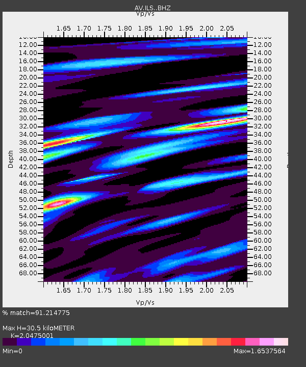
| Estimated Moho Depth: |
30.5 km |
| Estimated Crust Vp/Vs: |
2.05 |
| Assumed Crust Vp: |
5.989 km/s |
| Estimated Crust Vs: |
2.925 km/s |
| Estimated Crust Poisson's Ratio: |
0.34 |
|
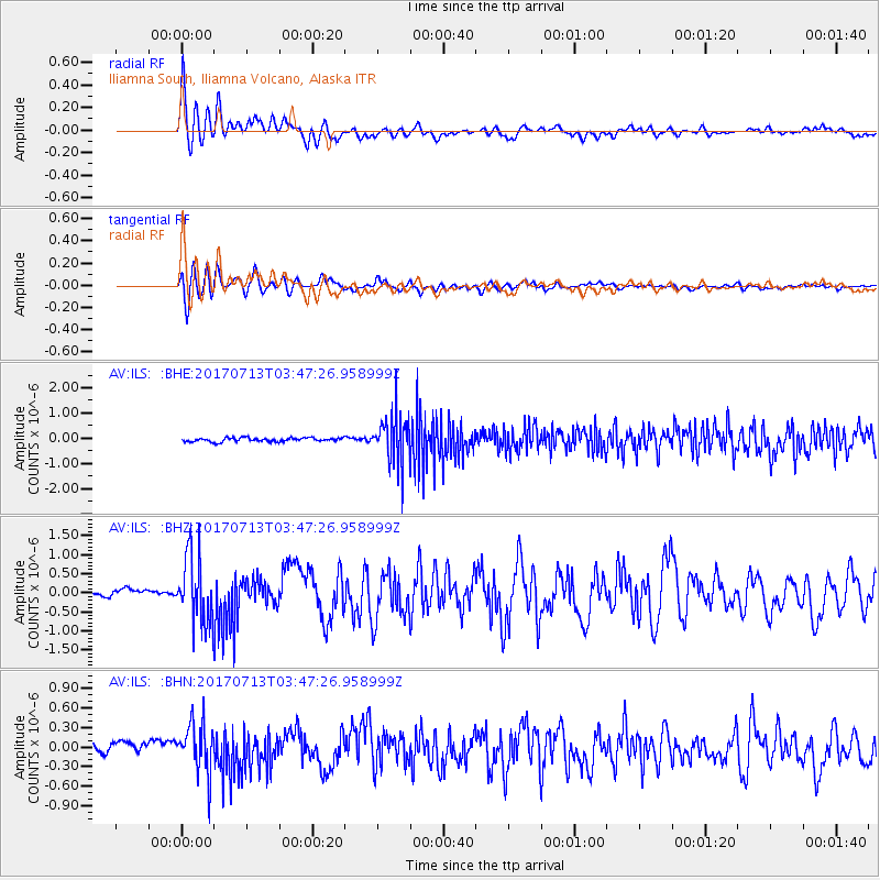
| Radial Match: |
91.214775 % |
| Radial Bump: |
400 |
| Transverse Match: |
83.20016 % |
| Transverse Bump: |
400 |
| SOD ConfigId: |
13570011 |
| Insert Time: |
2019-04-28 09:15:12.407 +0000 |
| GWidth: |
2.5 |
| Max Bumps: |
400 |
| Tol: |
0.001 |
|
Signal To Noise
| Channel | StoN | STA | LTA |
| AV:ILS: :BHZ:20170713T03:47:26.958999Z | 9.638186 | 9.2747644E-7 | 9.622936E-8 |
| AV:ILS: :BHN:20170713T03:47:26.958999Z | 3.2686114 | 3.7546758E-7 | 1.14870666E-7 |
| AV:ILS: :BHE:20170713T03:47:26.958999Z | 13.127902 | 9.733291E-7 | 7.4142015E-8 |
| Arrivals |
| Ps | 5.5 SECOND |
| PpPs | 15 SECOND |
| PsPs/PpSs | 21 SECOND |


