You are here: Home > Network List > TA - USArray Transportable Network (new EarthScope stations) Stations List
> Station R30A Dighton, KS, USA > Earthquake Result Viewer
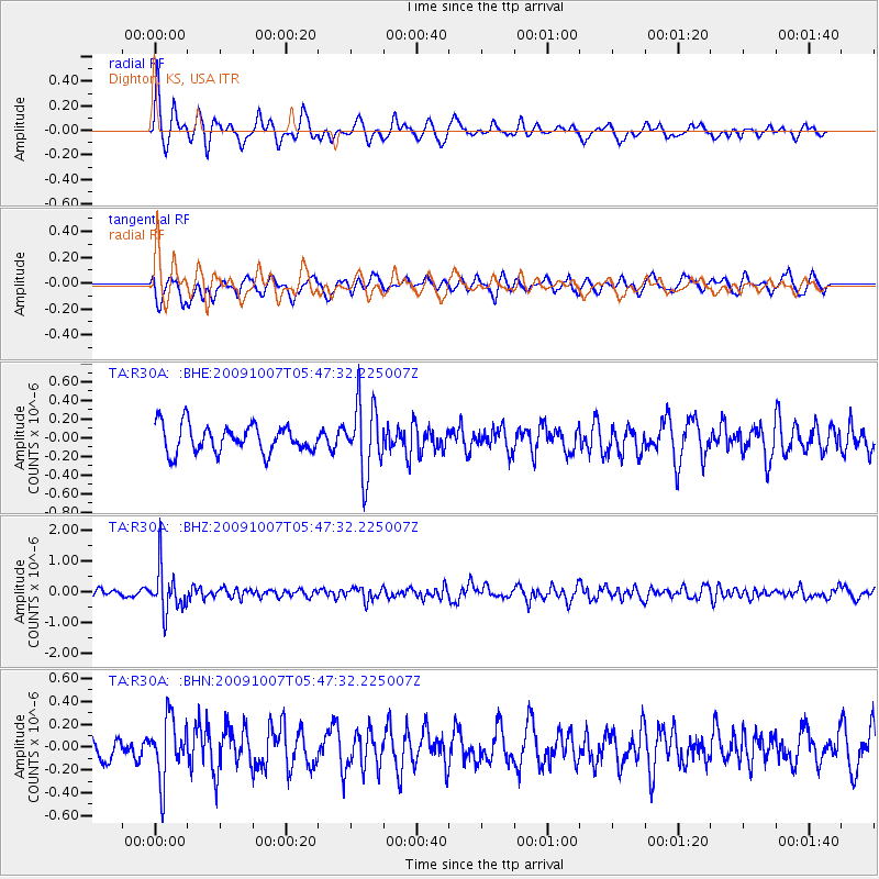
R30A Dighton, KS, USA - Earthquake Result Viewer
*The percent match for this event was below the threshold and hence no stack was calculated.
| Earthquake location: |
Rat Islands, Aleutian Islands |
| Earthquake latitude/longitude: |
52.2/178.1 |
| Earthquake time(UTC): |
2009/10/07 (280) 05:38:37 GMT |
| Earthquake Depth: |
138 km |
| Earthquake Magnitude: |
5.6 MB, 5.6 MW, 5.6 MW |
| Earthquake Catalog/Contributor: |
WHDF/NEIC |
|
| Network: |
TA USArray Transportable Network (new EarthScope stations) |
| Station: |
R30A Dighton, KS, USA |
| Lat/Lon: |
38.28 N/100.28 W |
| Elevation: |
776 m |
|
| Distance: |
56.2 deg |
| Az: |
69.552 deg |
| Baz: |
312.818 deg |
| Ray Param: |
$rayparam |
*The percent match for this event was below the threshold and hence was not used in the summary stack. |
|
| Radial Match: |
68.13709 % |
| Radial Bump: |
299 |
| Transverse Match: |
45.641712 % |
| Transverse Bump: |
368 |
| SOD ConfigId: |
2622 |
| Insert Time: |
2010-03-06 01:48:34.143 +0000 |
| GWidth: |
2.5 |
| Max Bumps: |
400 |
| Tol: |
0.001 |
|
Signal To Noise
| Channel | StoN | STA | LTA |
| TA:R30A: :BHZ:20091007T05:47:32.225007Z | 6.403332 | 7.0507053E-7 | 1.1010995E-7 |
| TA:R30A: :BHN:20091007T05:47:32.225007Z | 1.9329234 | 2.62777E-7 | 1.3594796E-7 |
| TA:R30A: :BHE:20091007T05:47:32.225007Z | 2.5635905 | 3.758832E-7 | 1.4662373E-7 |
| Arrivals |
| Ps | |
| PpPs | |
| PsPs/PpSs | |


