You are here: Home > Network List > CN - Canadian National Seismograph Network Stations List
> Station CBB Campbell River, BC, CA > Earthquake Result Viewer
CBB Campbell River, BC, CA - Earthquake Result Viewer
| Earthquake location: |
New Ireland Region, P.N.G. |
| Earthquake latitude/longitude: |
-4.8/153.2 |
| Earthquake time(UTC): |
2017/07/13 (194) 03:36:09 GMT |
| Earthquake Depth: |
47 km |
| Earthquake Magnitude: |
6.4 mww |
| Earthquake Catalog/Contributor: |
NEIC PDE/us |
|
| Network: |
CN Canadian National Seismograph Network |
| Station: |
CBB Campbell River, BC, CA |
| Lat/Lon: |
50.03 N/125.37 W |
| Elevation: |
277 m |
|
| Distance: |
88.2 deg |
| Az: |
39.65 deg |
| Baz: |
260.418 deg |
| Ray Param: |
0.042708028 |
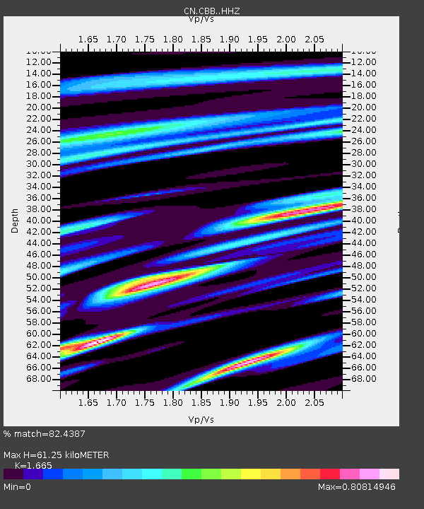
| Estimated Moho Depth: |
61.25 km |
| Estimated Crust Vp/Vs: |
1.66 |
| Assumed Crust Vp: |
6.566 km/s |
| Estimated Crust Vs: |
3.944 km/s |
| Estimated Crust Poisson's Ratio: |
0.22 |
|
| Radial Match: |
82.4387 % |
| Radial Bump: |
400 |
| Transverse Match: |
64.864845 % |
| Transverse Bump: |
400 |
| SOD ConfigId: |
13570011 |
| Insert Time: |
2019-04-28 09:16:45.408 +0000 |
| GWidth: |
2.5 |
| Max Bumps: |
400 |
| Tol: |
0.001 |
|

Signal To Noise
| Channel | StoN | STA | LTA |
| CN:CBB: :HHZ:20170713T03:48:24.750015Z | 8.213288 | 7.597178E-7 | 9.249862E-8 |
| CN:CBB: :HHN:20170713T03:48:24.750015Z | 0.718206 | 7.6060964E-8 | 1.05904114E-7 |
| CN:CBB: :HHE:20170713T03:48:24.750015Z | 3.0733025 | 2.2458353E-7 | 7.307563E-8 |
| Arrivals |
| Ps | 6.4 SECOND |
| PpPs | 24 SECOND |
| PsPs/PpSs | 31 SECOND |


