You are here: Home > Network List > CN - Canadian National Seismograph Network Stations List
> Station KITB Kitimat, BC, CA > Earthquake Result Viewer
KITB Kitimat, BC, CA - Earthquake Result Viewer
| Earthquake location: |
New Ireland Region, P.N.G. |
| Earthquake latitude/longitude: |
-4.8/153.2 |
| Earthquake time(UTC): |
2017/07/13 (194) 03:36:09 GMT |
| Earthquake Depth: |
47 km |
| Earthquake Magnitude: |
6.4 mww |
| Earthquake Catalog/Contributor: |
NEIC PDE/us |
|
| Network: |
CN Canadian National Seismograph Network |
| Station: |
KITB Kitimat, BC, CA |
| Lat/Lon: |
54.08 N/128.64 W |
| Elevation: |
72 m |
|
| Distance: |
87.0 deg |
| Az: |
35.285 deg |
| Baz: |
257.657 deg |
| Ray Param: |
0.04359484 |
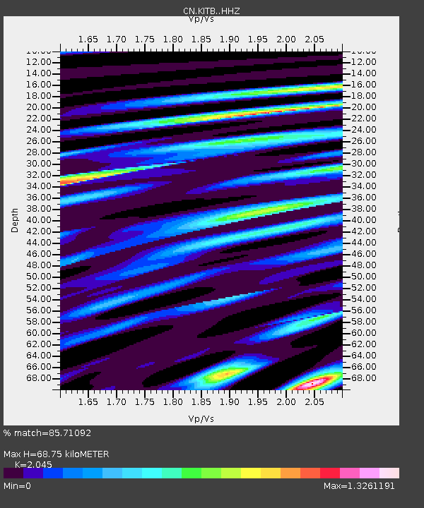
| Estimated Moho Depth: |
68.75 km |
| Estimated Crust Vp/Vs: |
2.05 |
| Assumed Crust Vp: |
6.438 km/s |
| Estimated Crust Vs: |
3.148 km/s |
| Estimated Crust Poisson's Ratio: |
0.34 |
|
| Radial Match: |
85.71092 % |
| Radial Bump: |
400 |
| Transverse Match: |
61.83872 % |
| Transverse Bump: |
400 |
| SOD ConfigId: |
13570011 |
| Insert Time: |
2019-04-28 09:16:57.432 +0000 |
| GWidth: |
2.5 |
| Max Bumps: |
400 |
| Tol: |
0.001 |
|

Signal To Noise
| Channel | StoN | STA | LTA |
| CN:KITB: :HHZ:20170713T03:48:18.938979Z | 6.4046655 | 9.0905706E-7 | 1.419367E-7 |
| CN:KITB: :HHN:20170713T03:48:18.938979Z | 0.6363636 | 7.7880124E-8 | 1.2238304E-7 |
| CN:KITB: :HHE:20170713T03:48:18.938979Z | 3.5626917 | 3.3844177E-7 | 9.499609E-8 |
| Arrivals |
| Ps | 11 SECOND |
| PpPs | 32 SECOND |
| PsPs/PpSs | 43 SECOND |


