You are here: Home > Network List > CN - Canadian National Seismograph Network Stations List
> Station MOBC Moresby, BC, CA > Earthquake Result Viewer
MOBC Moresby, BC, CA - Earthquake Result Viewer
| Earthquake location: |
New Ireland Region, P.N.G. |
| Earthquake latitude/longitude: |
-4.8/153.2 |
| Earthquake time(UTC): |
2017/07/13 (194) 03:36:09 GMT |
| Earthquake Depth: |
47 km |
| Earthquake Magnitude: |
6.4 mww |
| Earthquake Catalog/Contributor: |
NEIC PDE/us |
|
| Network: |
CN Canadian National Seismograph Network |
| Station: |
MOBC Moresby, BC, CA |
| Lat/Lon: |
53.14 N/131.97 W |
| Elevation: |
675 m |
|
| Distance: |
84.8 deg |
| Az: |
35.726 deg |
| Baz: |
255.015 deg |
| Ray Param: |
0.045137454 |
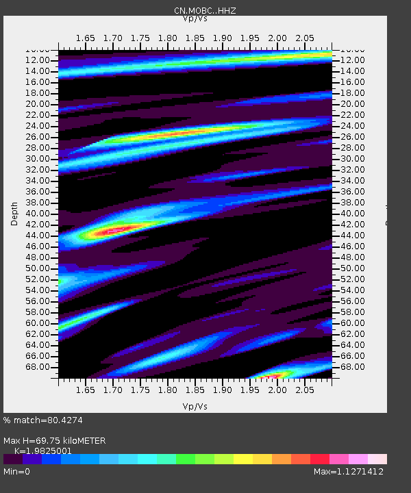
| Estimated Moho Depth: |
69.75 km |
| Estimated Crust Vp/Vs: |
1.98 |
| Assumed Crust Vp: |
6.134 km/s |
| Estimated Crust Vs: |
3.094 km/s |
| Estimated Crust Poisson's Ratio: |
0.33 |
|
| Radial Match: |
80.4274 % |
| Radial Bump: |
317 |
| Transverse Match: |
61.67114 % |
| Transverse Bump: |
400 |
| SOD ConfigId: |
13570011 |
| Insert Time: |
2019-04-28 09:16:58.641 +0000 |
| GWidth: |
2.5 |
| Max Bumps: |
400 |
| Tol: |
0.001 |
|

Signal To Noise
| Channel | StoN | STA | LTA |
| CN:MOBC: :HHZ:20170713T03:48:08.33998Z | 3.1409683 | 7.485378E-7 | 2.3831434E-7 |
| CN:MOBC: :HHN:20170713T03:48:08.33998Z | 1.5370435 | 2.7911383E-7 | 1.8159136E-7 |
| CN:MOBC: :HHE:20170713T03:48:08.33998Z | 1.7694769 | 4.7260863E-7 | 2.6708946E-7 |
| Arrivals |
| Ps | 11 SECOND |
| PpPs | 33 SECOND |
| PsPs/PpSs | 45 SECOND |


