You are here: Home > Network List > TA - USArray Transportable Network (new EarthScope stations) Stations List
> Station Q28A Sharon Springs, KS, USA > Earthquake Result Viewer
Q28A Sharon Springs, KS, USA - Earthquake Result Viewer
| Earthquake location: |
Near S. Coast Of Honshu, Japan |
| Earthquake latitude/longitude: |
33.2/137.9 |
| Earthquake time(UTC): |
2009/08/09 (221) 10:55:55 GMT |
| Earthquake Depth: |
297 km |
| Earthquake Magnitude: |
6.5 MB, 7.1 MW, 7.1 MW |
| Earthquake Catalog/Contributor: |
WHDF/NEIC |
|
| Network: |
TA USArray Transportable Network (new EarthScope stations) |
| Station: |
Q28A Sharon Springs, KS, USA |
| Lat/Lon: |
39.06 N/101.83 W |
| Elevation: |
1133 m |
|
| Distance: |
89.3 deg |
| Az: |
42.278 deg |
| Baz: |
313.55 deg |
| Ray Param: |
0.04168836 |
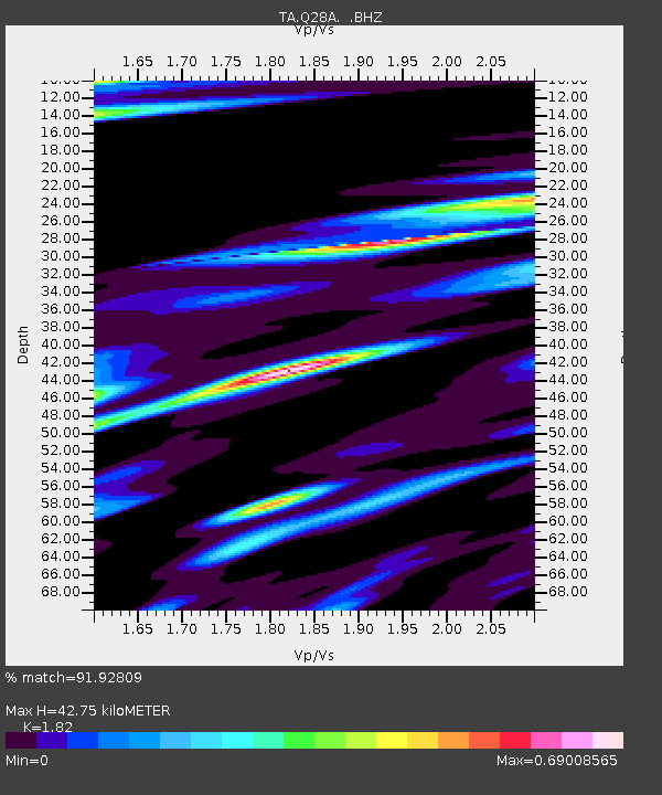
| Estimated Moho Depth: |
42.75 km |
| Estimated Crust Vp/Vs: |
1.82 |
| Assumed Crust Vp: |
6.483 km/s |
| Estimated Crust Vs: |
3.562 km/s |
| Estimated Crust Poisson's Ratio: |
0.28 |
|
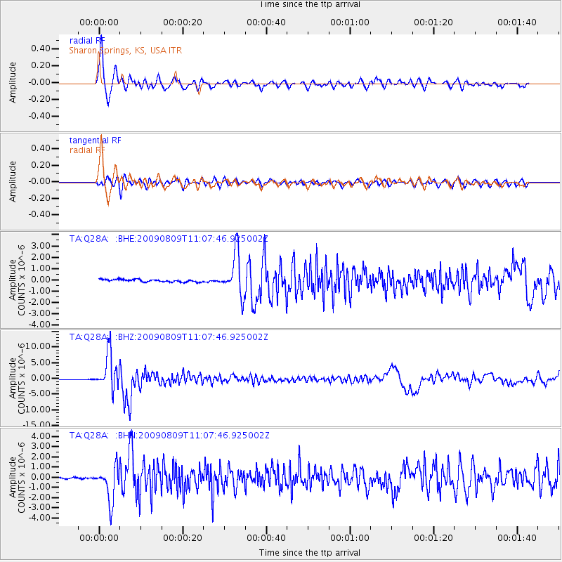
| Radial Match: |
91.92809 % |
| Radial Bump: |
400 |
| Transverse Match: |
80.30371 % |
| Transverse Bump: |
400 |
| SOD ConfigId: |
2622 |
| Insert Time: |
2010-03-06 01:48:52.853 +0000 |
| GWidth: |
2.5 |
| Max Bumps: |
400 |
| Tol: |
0.001 |
|
Signal To Noise
| Channel | StoN | STA | LTA |
| TA:Q28A: :BHZ:20090809T11:07:46.925002Z | 70.791504 | 5.816382E-6 | 8.2162146E-8 |
| TA:Q28A: :BHN:20090809T11:07:46.925002Z | 17.795269 | 1.7270625E-6 | 9.7051775E-8 |
| TA:Q28A: :BHE:20090809T11:07:46.925002Z | 17.065718 | 1.8843293E-6 | 1.1041606E-7 |
| Arrivals |
| Ps | 5.5 SECOND |
| PpPs | 18 SECOND |
| PsPs/PpSs | 24 SECOND |


