You are here: Home > Network List > TA - USArray Transportable Network (new EarthScope stations) Stations List
> Station Q28A Sharon Springs, KS, USA > Earthquake Result Viewer
Q28A Sharon Springs, KS, USA - Earthquake Result Viewer

| Earthquake location: |
West Chile Rise |
| Earthquake latitude/longitude: |
-41.7/-84.0 |
| Earthquake time(UTC): |
2009/06/10 (161) 23:13:21 GMT |
| Earthquake Depth: |
10 km |
| Earthquake Magnitude: |
5.7 MB, 5.2 MS, 5.7 MW, 5.6 MW |
| Earthquake Catalog/Contributor: |
WHDF/NEIC |
|
| Network: |
TA USArray Transportable Network (new EarthScope stations) |
| Station: |
Q28A Sharon Springs, KS, USA |
| Lat/Lon: |
39.06 N/101.83 W |
| Elevation: |
1133 m |
|
| Distance: |
82.0 deg |
| Az: |
346.067 deg |
| Baz: |
166.612 deg |
| Ray Param: |
0.047175363 |
| Estimated Moho Depth: |
62.25 km |
| Estimated Crust Vp/Vs: |
1.97 |
| Assumed Crust Vp: |
6.483 km/s |
| Estimated Crust Vs: |
3.286 km/s |
| Estimated Crust Poisson's Ratio: |
0.33 |
|
| Radial Match: |
84.68656 % |
| Radial Bump: |
400 |
| Transverse Match: |
75.34304 % |
| Transverse Bump: |
400 |
| SOD ConfigId: |
2648 |
| Insert Time: |
2010-03-06 01:49:19.705 +0000 |
| GWidth: |
2.5 |
| Max Bumps: |
400 |
| Tol: |
0.001 |
|
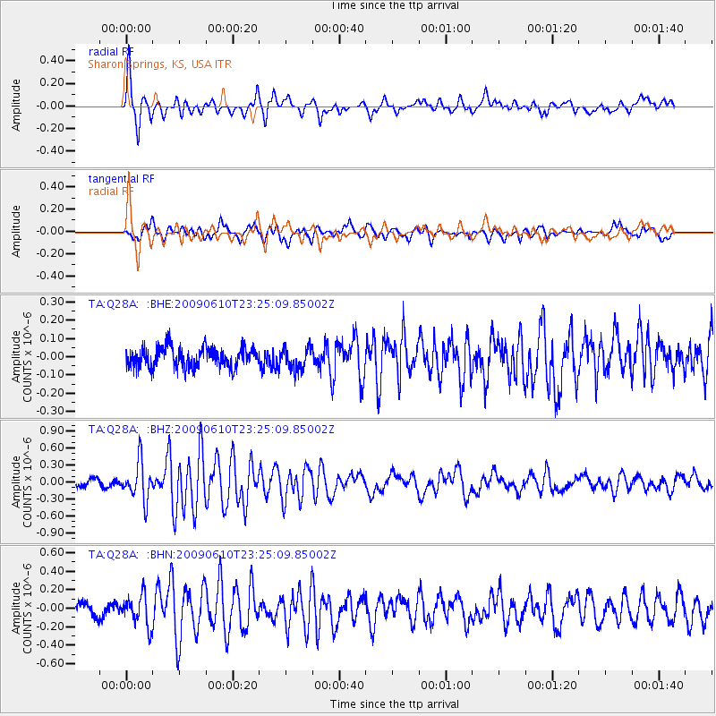
Signal To Noise
| Channel | StoN | STA | LTA |
| TA:Q28A: :BHZ:20090610T23:25:09.85002Z | 5.3475366 | 3.4084522E-7 | 6.373873E-8 |
| TA:Q28A: :BHN:20090610T23:25:09.85002Z | 2.2618568 | 1.6829277E-7 | 7.4404696E-8 |
| TA:Q28A: :BHE:20090610T23:25:09.85002Z | 1.1086462 | 5.9784185E-8 | 5.39254E-8 |
| Arrivals |
| Ps | 9.6 SECOND |
| PpPs | 28 SECOND |
| PsPs/PpSs | 37 SECOND |


