You are here: Home > Network List > RV - Regional Alberta Seismic Observatory for Earthquake Studies Network Stations List
> Station FAIRA Fairview, AB > Earthquake Result Viewer
FAIRA Fairview, AB - Earthquake Result Viewer
| Earthquake location: |
New Ireland Region, P.N.G. |
| Earthquake latitude/longitude: |
-4.8/153.2 |
| Earthquake time(UTC): |
2017/07/13 (194) 03:36:09 GMT |
| Earthquake Depth: |
47 km |
| Earthquake Magnitude: |
6.4 mww |
| Earthquake Catalog/Contributor: |
NEIC PDE/us |
|
| Network: |
RV Regional Alberta Seismic Observatory for Earthquake Studies Network |
| Station: |
FAIRA Fairview, AB |
| Lat/Lon: |
56.11 N/118.86 W |
| Elevation: |
642 m |
|
| Distance: |
92.8 deg |
| Az: |
34.092 deg |
| Baz: |
265.658 deg |
| Ray Param: |
0.041366003 |
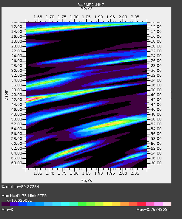
| Estimated Moho Depth: |
41.75 km |
| Estimated Crust Vp/Vs: |
1.60 |
| Assumed Crust Vp: |
6.444 km/s |
| Estimated Crust Vs: |
4.021 km/s |
| Estimated Crust Poisson's Ratio: |
0.18 |
|
| Radial Match: |
80.37284 % |
| Radial Bump: |
341 |
| Transverse Match: |
55.19258 % |
| Transverse Bump: |
400 |
| SOD ConfigId: |
13570011 |
| Insert Time: |
2019-04-28 09:19:27.025 +0000 |
| GWidth: |
2.5 |
| Max Bumps: |
400 |
| Tol: |
0.001 |
|

Signal To Noise
| Channel | StoN | STA | LTA |
| RV:FAIRA: :HHZ:20170713T03:48:46.260024Z | 9.29965 | 9.112287E-7 | 9.7985264E-8 |
| RV:FAIRA: :HHN:20170713T03:48:46.260024Z | 1.5193202 | 2.5258777E-7 | 1.6625052E-7 |
| RV:FAIRA: :HHE:20170713T03:48:46.260024Z | 1.3218747 | 3.402265E-7 | 2.573818E-7 |
| Arrivals |
| Ps | 4.0 SECOND |
| PpPs | 16 SECOND |
| PsPs/PpSs | 20 SECOND |


