You are here: Home > Network List > TA - USArray Transportable Network (new EarthScope stations) Stations List
> Station E27K Coleen River, AK, USA > Earthquake Result Viewer
E27K Coleen River, AK, USA - Earthquake Result Viewer
| Earthquake location: |
New Ireland Region, P.N.G. |
| Earthquake latitude/longitude: |
-4.8/153.2 |
| Earthquake time(UTC): |
2017/07/13 (194) 03:36:09 GMT |
| Earthquake Depth: |
47 km |
| Earthquake Magnitude: |
6.4 mww |
| Earthquake Catalog/Contributor: |
NEIC PDE/us |
|
| Network: |
TA USArray Transportable Network (new EarthScope stations) |
| Station: |
E27K Coleen River, AK, USA |
| Lat/Lon: |
68.19 N/141.60 W |
| Elevation: |
654 m |
|
| Distance: |
85.5 deg |
| Az: |
19.906 deg |
| Baz: |
245.206 deg |
| Ray Param: |
0.04466709 |
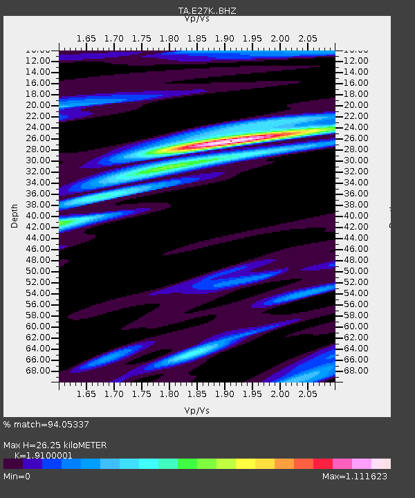
| Estimated Moho Depth: |
26.25 km |
| Estimated Crust Vp/Vs: |
1.91 |
| Assumed Crust Vp: |
6.522 km/s |
| Estimated Crust Vs: |
3.414 km/s |
| Estimated Crust Poisson's Ratio: |
0.31 |
|
| Radial Match: |
94.05337 % |
| Radial Bump: |
400 |
| Transverse Match: |
81.14101 % |
| Transverse Bump: |
400 |
| SOD ConfigId: |
13570011 |
| Insert Time: |
2019-04-28 09:19:56.464 +0000 |
| GWidth: |
2.5 |
| Max Bumps: |
400 |
| Tol: |
0.001 |
|

Signal To Noise
| Channel | StoN | STA | LTA |
| TA:E27K: :BHZ:20170713T03:48:11.649978Z | 39.11186 | 1.2434648E-6 | 3.1792524E-8 |
| TA:E27K: :BHN:20170713T03:48:11.649978Z | 4.8527637 | 1.4562558E-7 | 3.0008795E-8 |
| TA:E27K: :BHE:20170713T03:48:11.649978Z | 10.724017 | 4.056854E-7 | 3.782961E-8 |
| Arrivals |
| Ps | 3.7 SECOND |
| PpPs | 11 SECOND |
| PsPs/PpSs | 15 SECOND |


