You are here: Home > Network List > TA - USArray Transportable Network (new EarthScope stations) Stations List
> Station F25K Christian River, AK, USA > Earthquake Result Viewer
F25K Christian River, AK, USA - Earthquake Result Viewer
| Earthquake location: |
New Ireland Region, P.N.G. |
| Earthquake latitude/longitude: |
-4.8/153.2 |
| Earthquake time(UTC): |
2017/07/13 (194) 03:36:09 GMT |
| Earthquake Depth: |
47 km |
| Earthquake Magnitude: |
6.4 mww |
| Earthquake Catalog/Contributor: |
NEIC PDE/us |
|
| Network: |
TA USArray Transportable Network (new EarthScope stations) |
| Station: |
F25K Christian River, AK, USA |
| Lat/Lon: |
67.59 N/145.64 W |
| Elevation: |
864 m |
|
| Distance: |
83.8 deg |
| Az: |
19.749 deg |
| Baz: |
241.445 deg |
| Ray Param: |
0.045830257 |
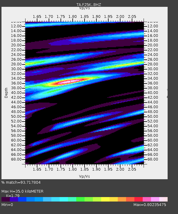
| Estimated Moho Depth: |
35.0 km |
| Estimated Crust Vp/Vs: |
1.79 |
| Assumed Crust Vp: |
6.522 km/s |
| Estimated Crust Vs: |
3.643 km/s |
| Estimated Crust Poisson's Ratio: |
0.27 |
|
| Radial Match: |
93.717804 % |
| Radial Bump: |
400 |
| Transverse Match: |
81.47417 % |
| Transverse Bump: |
400 |
| SOD ConfigId: |
13570011 |
| Insert Time: |
2019-04-28 09:20:01.438 +0000 |
| GWidth: |
2.5 |
| Max Bumps: |
400 |
| Tol: |
0.001 |
|

Signal To Noise
| Channel | StoN | STA | LTA |
| TA:F25K: :BHZ:20170713T03:48:03.425002Z | 21.103958 | 1.1424578E-6 | 5.4134766E-8 |
| TA:F25K: :BHN:20170713T03:48:03.425002Z | 4.6703453 | 2.1134707E-7 | 4.525299E-8 |
| TA:F25K: :BHE:20170713T03:48:03.425002Z | 9.824047 | 3.4054068E-7 | 3.466399E-8 |
| Arrivals |
| Ps | 4.4 SECOND |
| PpPs | 15 SECOND |
| PsPs/PpSs | 19 SECOND |


