You are here: Home > Network List > TA - USArray Transportable Network (new EarthScope stations) Stations List
> Station H24K Noodor Dome, AK, USA > Earthquake Result Viewer
H24K Noodor Dome, AK, USA - Earthquake Result Viewer
| Earthquake location: |
New Ireland Region, P.N.G. |
| Earthquake latitude/longitude: |
-4.8/153.2 |
| Earthquake time(UTC): |
2017/07/13 (194) 03:36:09 GMT |
| Earthquake Depth: |
47 km |
| Earthquake Magnitude: |
6.4 mww |
| Earthquake Catalog/Contributor: |
NEIC PDE/us |
|
| Network: |
TA USArray Transportable Network (new EarthScope stations) |
| Station: |
H24K Noodor Dome, AK, USA |
| Lat/Lon: |
65.84 N/147.88 W |
| Elevation: |
814 m |
|
| Distance: |
82.2 deg |
| Az: |
20.855 deg |
| Baz: |
239.528 deg |
| Ray Param: |
0.046982087 |
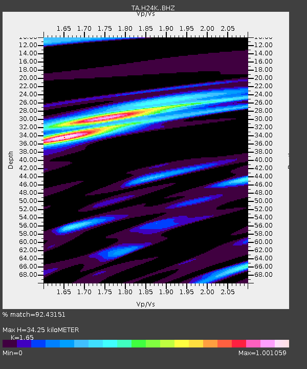
| Estimated Moho Depth: |
34.25 km |
| Estimated Crust Vp/Vs: |
1.65 |
| Assumed Crust Vp: |
6.566 km/s |
| Estimated Crust Vs: |
3.98 km/s |
| Estimated Crust Poisson's Ratio: |
0.21 |
|
| Radial Match: |
92.43151 % |
| Radial Bump: |
400 |
| Transverse Match: |
76.64275 % |
| Transverse Bump: |
400 |
| SOD ConfigId: |
13570011 |
| Insert Time: |
2019-04-28 09:20:17.648 +0000 |
| GWidth: |
2.5 |
| Max Bumps: |
400 |
| Tol: |
0.001 |
|
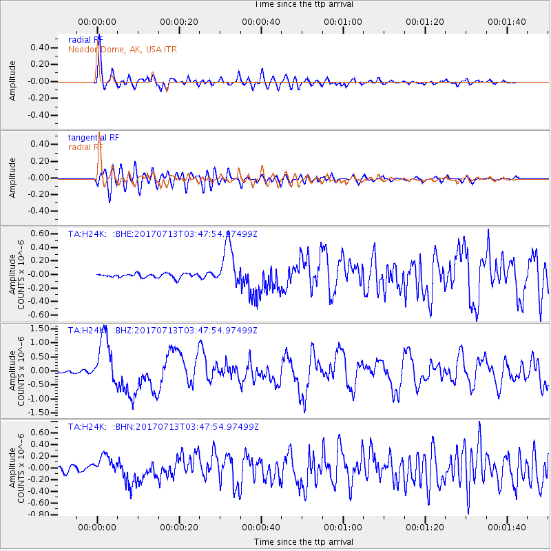
Signal To Noise
| Channel | StoN | STA | LTA |
| TA:H24K: :BHZ:20170713T03:47:54.97499Z | 17.396767 | 9.078697E-7 | 5.2186117E-8 |
| TA:H24K: :BHN:20170713T03:47:54.97499Z | 4.6323533 | 1.6865258E-7 | 3.640754E-8 |
| TA:H24K: :BHE:20170713T03:47:54.97499Z | 10.815434 | 3.2155918E-7 | 2.9731508E-8 |
| Arrivals |
| Ps | 3.5 SECOND |
| PpPs | 13 SECOND |
| PsPs/PpSs | 17 SECOND |


